
Carte topographique Ipswich
Carte interactive
Cliquez sur la carte pour afficher l’altitude.
À propos de cette carte
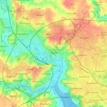
Nom : Carte topographique Ipswich, altitude, relief.
Lieu : Ipswich, Suffolk, England, United Kingdom (52.02016 1.10725 52.09445 1.22365)
Altitude moyenne : 29 m
Altitude minimum : -3 m
Altitude maximum : 56 m
Ipswich experiences an oceanic climate, like the rest of the British Isles, with a narrow range of temperature and rainfall spread evenly throughout the year. One of the two nearest for which data is available is East Bergholt, about 7 miles (11 km) south west of the town centre and at a similar elevation, and similar river valley/estuary situation. The average July maximum of 23.2 °C (73.8 °F) is the third-highest for a major settlement in the country, behind London and Colchester, illustrating the relative warmth of the area during the summer part of the year. The record maximum is 35.2 °C (95.4 °F), set during August 2003. Typically, 24.9 days of the year will record a maximum temperature of 25.1 °C (77.2 °F) or above, and the warmest day of the year should reach 30.0 °C (86.0 °F), on average.
Autres cartes topographiques
Cliquez sur une carte pour visualiser sa topographie, son altitude et son relief.
Stowmarket
United Kingdom > England > Suffolk > Mid Suffolk
Stowmarket, Mid Suffolk, Suffolk, England, United Kingdom
Altitude moyenne : 46 m
Lakenheath
United Kingdom > England > Suffolk > West Suffolk
Lakenheath, West Suffolk, Suffolk, England, IP27 9JS, United Kingdom
Altitude moyenne : 6 m