
Carte topographique Seang Aonach Mor
Carte interactive
Cliquez sur la carte pour afficher l’altitude.
À propos de cette carte
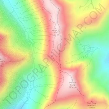
Nom : Carte topographique Seang Aonach Mor, altitude, relief.
Lieu : Seang Aonach Mor, Highland, Scotland, United Kingdom (56.79645 -4.97226 56.81645 -4.95226)
Altitude moyenne : 895 m
Altitude minimum : 552 m
Altitude maximum : 1 234 m
Autres cartes topographiques
Cliquez sur une carte pour visualiser sa topographie, son altitude et son relief.
Loch Lochy
United Kingdom > Scotland > Highland
Loch Lochy, Highland, Scotland, United Kingdom
Altitude moyenne : 363 m
Aonach Mòr
United Kingdom > Scotland > Highland
Aonach Mòr, Highland, Scotland, United Kingdom
Altitude moyenne : 533 m
Roybridge
United Kingdom > Scotland > Highland
Roybridge, Highland, Scotland, PH31 4AE, United Kingdom
Altitude moyenne : 178 m
Inverroy
United Kingdom > Scotland > Highland
Inverroy, Highland, Scotland, PH31 4AQ, United Kingdom
Altitude moyenne : 167 m
Stob Choire Claurigh
United Kingdom > Scotland > Highland
Stob Choire Claurigh, Highland, Scotland, United Kingdom
Altitude moyenne : 852 m
Aonach Beag
United Kingdom > Scotland > Highland
Aonach Beag, Highland, Scotland, United Kingdom
Altitude moyenne : 825 m
Ballachulish
United Kingdom > Scotland > Highland
Ballachulish, Highland, Scotland, PH49 4JU, United Kingdom
Altitude moyenne : 160 m
Glen Nevis
United Kingdom > Scotland > Highland
Glen Nevis, Highland, Scotland, PH33 6TE, United Kingdom
Altitude moyenne : 178 m
Strathcarron
United Kingdom > Scotland > Highland
Strathcarron, Highland, Scotland, IV54 8YR, United Kingdom
Altitude moyenne : 91 m
Ullapool
United Kingdom > Scotland > Highland
Ullapool, Highland, Scotland, IV26 2XE, United Kingdom
Altitude moyenne : 150 m
Ben More Assynt
United Kingdom > Scotland > Highland
Ben More Assynt, Highland, Scotland, United Kingdom
Altitude moyenne : 679 m
Nybster
United Kingdom > Scotland > Highland
Nybster, Highland, Scotland, KW1 4XR, United Kingdom
Altitude moyenne : 30 m
Glen Coe
United Kingdom > Scotland > Highland > Glencoe
Glen Coe, Glencoe, Highland, Scotland, United Kingdom
Altitude moyenne : 414 m
Loch Bealach nam Buthan
United Kingdom > Scotland > Highland
Loch Bealach nam Buthan, Highland, Scotland, United Kingdom
Altitude moyenne : 586 m
Inverlochy
United Kingdom > Scotland > Highland > Inverlochy
Inverlochy, Highland, Scotland, PH33 6NB, United Kingdom
Altitude moyenne : 48 m
Golspie
United Kingdom > Scotland > Highland > Golspie
Golspie, Highland, Scotland, KW10 6TF, United Kingdom
Altitude moyenne : 61 m
Loch Shin
United Kingdom > Scotland > Highland > Lairg
Loch Shin, Lairg, Highland, Scotland, United Kingdom
Altitude moyenne : 217 m
Ben Nevis
United Kingdom > Scotland > Highland
Ben Nevis, Highland, Scotland, United Kingdom
Altitude moyenne : 912 m
Fort William
United Kingdom > Scotland > Highland
Fort William, Highland, Scotland, PH33 6AQ, United Kingdom
Altitude moyenne : 122 m
Inver
United Kingdom > Scotland > Highland
Inver, Highland, Scotland, IV20 1RY, United Kingdom
Altitude moyenne : 8 m
Castletown
United Kingdom > Scotland > Highland
Castletown, Highland, Scotland, KW14 8UE, United Kingdom
Altitude moyenne : 25 m
Kilmore
United Kingdom > Scotland > Highland > Ferindonald
Kilmore, Sleat, Ferindonald, Highland, Scotland, IV44 8RG, United Kingdom
Altitude moyenne : 61 m