
Carte topographique Vail
Carte interactive
Cliquez sur la carte pour afficher l’altitude.
Vail
Vail's average elevation is 8,150 feet (2,480 m) above sea level. The town has a total area of 4.5 square miles (12 km2), with no lakes (there is, however, at least one pond). Gore Creek flows from east to west through the center of town.
À propos de cette carte
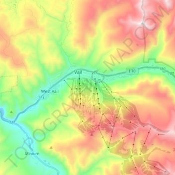
Nom : Carte topographique Vail, altitude, relief.
Lieu : Vail, Eagle County, Colorado, 81657, United States (39.61496 -106.43944 39.65077 -106.27975)
Altitude moyenne : 2 953 m
Altitude minimum : 2 342 m
Altitude maximum : 3 692 m
Autres cartes topographiques
Cliquez sur une carte pour visualiser sa topographie, son altitude et son relief.
Vail
United States > Colorado > Eagle County
Vail's average elevation is 8,150 feet (2,480 m) above sea level. The town has a total area of 4.5 square miles (12 km2), with no lakes (there is, however, at least one pond). Gore Creek flows from east to west through the center of town.
Altitude moyenne : 2 935 m