
Carte topographique Horowhenua District
Carte interactive
Cliquez sur la carte pour afficher l’altitude.
À propos de cette carte
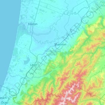
Nom : Carte topographique Horowhenua District, altitude, relief.
Lieu : Horowhenua District, Manawatū-Whanganui, New Zealand (-40.76871 175.13535 -40.38595 175.62534)
Altitude moyenne : 222 m
Altitude minimum : -1 m
Altitude maximum : 1 479 m
Autres cartes topographiques
Cliquez sur une carte pour visualiser sa topographie, son altitude et son relief.
Foxton
New Zealand > Manawatu-Whanganui > Horowhenua District
Foxton, Horowhenua District, Manawatū-Whanganui, 4814, New Zealand
Altitude moyenne : 10 m
Levin
New Zealand > Manawatu-Whanganui > Horowhenua District
Levin, Horowhenua District, Manawatū-Whanganui, 5510, New Zealand
Altitude moyenne : 41 m