
Carte topographique Xiashan District
Carte interactive
Cliquez sur la carte pour afficher l’altitude.
À propos de cette carte
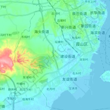
Nom : Carte topographique Xiashan District, altitude, relief.
Lieu : Xiashan District, Zhanjiang City, Guangdong, PRC (21.12049 110.31531 21.24295 110.44235)
Altitude moyenne : 22 m
Altitude minimum : -4 m
Altitude maximum : 157 m
Autres cartes topographiques
Cliquez sur une carte pour visualiser sa topographie, son altitude et son relief.
Science City
PRC > Guangdong > Guangzhou City
Science City, 联和街道, Huangpu District, Guangzhou City, Guangdong, PRC
Altitude moyenne : 27 m
Baiyun District
PRC > Guangdong > Guangzhou City
Baiyun District, Guangzhou City, Guangdong, PRC
Altitude moyenne : 40 m