
Carte topographique Meares Glacier
Carte interactive
Cliquez sur la carte pour afficher l’altitude.
À propos de cette carte
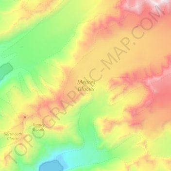
Nom : Carte topographique Meares Glacier, altitude, relief.
Lieu : Meares Glacier, Valdez-Cordova, Alaska, USA (61.14198 -147.52951 61.29129 -147.21898)
Altitude moyenne : 1 156 m
Altitude minimum : 0 m
Altitude maximum : 2 821 m
Autres cartes topographiques
Cliquez sur une carte pour visualiser sa topographie, son altitude et son relief.
Mendenhaven
USA > Alaska > Mendenhaven
Mendenhaven, Juneau, Alaska, 99801, USA
Altitude moyenne : 126 m
Matanuska Glacier
Matanuska Glacier, Matanuska-Susitna, Alaska, USA
Altitude moyenne : 1 819 m
Kahiltna Glacier
Kahiltna Glacier, Matanuska-Susitna, Alaska, USA
Altitude moyenne : 1 497 m
Shadows Glacier
Shadows Glacier, Matanuska-Susitna, Alaska, USA
Altitude moyenne : 1 464 m
Explorer Glacier
Explorer Glacier, Trail of Blue Ice, Anchorage, Alaska, USA
Altitude moyenne : 559 m
Kuskokwim River
Kuskokwim River, Unorganized Borough, Alaska, USA
Altitude moyenne : 111 m
Robertson River
Robertson River, Unorganized Borough, Alaska, USA
Altitude moyenne : 1 080 m
Byron Glacier
Byron Glacier, Byron Glacier Trail, Anchorage, Alaska, USA
Altitude moyenne : 749 m
Admiralty Island
Admiralty Island, Hoonah-Angoon, Alaska, 99820, USA
Altitude moyenne : 295 m
Chenega Glacier
Chenega Glacier, Unorganized Borough, Alaska, USA
Altitude moyenne : 752 m
Cul-de-Sac Glacier
Cul-de-Sac Glacier, Matanuska-Susitna, Alaska, USA
Altitude moyenne : 1 541 m
Worthington Glacier
Worthington Glacier, Richardson Highway, Ptarmigan, Valdez-Cordova, Alaska, USA
Altitude moyenne : 1 356 m
Madre de Dios Island
Madre de Dios Island, Prince of Wales-Hyder, Alaska, USA
Altitude moyenne : 12 m
Mitkof Island
Mitkof Island, Petersburg Borough, Alaska, 99833, USA
Altitude moyenne : 154 m