
Carte topographique Cooke Creek
Cliquez sur la carte pour afficher l’altitude.
À propos de cette carte
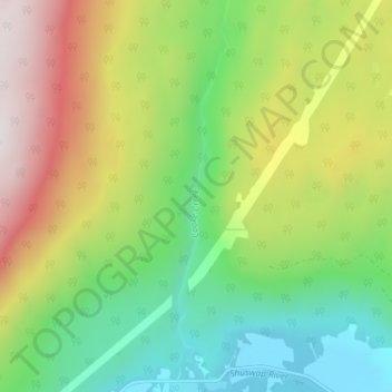
Nom : Carte topographique Cooke Creek, altitude, relief.
Altitude moyenne : 838 m
Altitude minimum : 367 m
Altitude maximum : 1 575 m
Autres cartes topographiques
Cliquez sur une carte pour visualiser sa topographie, son altitude et son relief.
Grindrod
Canada > British Columbia > Regional District of North Okanagan > Area F (Grindrod/Ashton Creek/Mabel Lake)
Altitude moyenne : 406 m
Mabel Lake
Canada > British Columbia > Regional District of North Okanagan > Area F (Grindrod/Ashton Creek/Mabel Lake)
Altitude moyenne : 1 164 m
Monashee Mountains
Canada > British Columbia > Regional District of North Okanagan > Area F (Grindrod/Ashton Creek/Mabel Lake)
Altitude moyenne : 1 685 m