
Carte topographique Hoon Hay
Carte interactive
Cliquez sur la carte pour afficher l’altitude.
À propos de cette carte
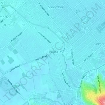
Nom : Carte topographique Hoon Hay, altitude, relief.
Altitude moyenne : 16 m
Altitude minimum : 8 m
Altitude maximum : 110 m
Autres cartes topographiques
Cliquez sur une carte pour visualiser sa topographie, son altitude et son relief.
New Brighton
New Zealand > Canterbury > Christchurch
New Brighton, Christchurch, Canterbury, New Zealand
Altitude moyenne : 3 m
Papanui
New Zealand > Canterbury > Christchurch
Papanui, Frank Street, Papanui, Christchurch, Christchurch City, Canterbury, 8052, New Zealand
Altitude moyenne : 14 m
Godley Head
New Zealand > Canterbury > Christchurch
Godley Head, Linwood-Central-Heathcote Community, Christchurch, Christchurch City, Canterbury, New Zealand
Altitude moyenne : 25 m
Halswell River
New Zealand > Canterbury > Christchurch
Halswell River, Christchurch, Selwyn District, Canterbury, 7674, New Zealand
Altitude moyenne : 15 m
Te Oranga Waikura
New Zealand > Canterbury > Christchurch
Te Oranga Waikura, Woolston, Christchurch, Christchurch City, Canterbury, New Zealand
Altitude moyenne : 5 m
Papanui Stream
New Zealand > Canterbury > Christchurch
Papanui Stream, Christchurch, Christchurch City, Canterbury, 8052, New Zealand
Altitude moyenne : 12 m
Kumara Reserve
New Zealand > Canterbury > Christchurch
Kumara Reserve, Hei Hei, Christchurch, Christchurch City, Canterbury, New Zealand
Altitude moyenne : 34 m