
Faire un don
Équipez-vous pour votre prochaine aventure :
En tant que Partenaire Amazon, ce site perçoit une commission sur les achats éligibles sans surcoût pour vous.
Carte topographique Thanjavur
Cliquez sur la carte pour afficher l’altitude.
Faire un don
Équipez-vous pour votre prochaine aventure :
En tant que Partenaire Amazon, ce site perçoit une commission sur les achats éligibles sans surcoût pour vous.
Thanjavur
Thanjavur is located at 10°48′N 79°09′E / 10.8°N 79.15°E / 10.8; 79.15 The tributaries of river Cauvery, namely, the Grand Anaicut canal (Pudhaaru), Vadavaaru and Vennaaru rivers flow through the city. Thanjavur is situated in the Cauvery delta, at a distance of 314 km (195 mi) south-west of Chennai and 56 km (35 mi) east of Tiruchirappalli. While the plains immediately adjoining the Cauvery river have been under cultivation from time immemorial, most of Thanjavur city and the surrounding areas lie in the "New Delta" – a dry, barren upland tract which was brought under irrigation during the early 19th century. To the south of Thanjavur city, is the Vallam tableland, a small plateau interspersed at regular intervals by ridges of sandstone. The nearest seaport is Nagapattinam which is 84 km (52 mi) east of Thanjavur. The nearest airport is Tiruchirapalli International Airport, located at a distance of 56 km (35 mi). The city has an elevation of 59 m (194 ft) above mean sea level. The total area of the city is 36.33 km2 (14.03 sq mi).
Faire un don
Équipez-vous pour votre prochaine aventure :
En tant que Partenaire Amazon, ce site perçoit une commission sur les achats éligibles sans surcoût pour vous.
À propos de cette carte
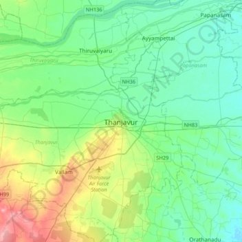
Nom : Carte topographique Thanjavur, altitude, relief.
Lieu : Thanjavur, Tamil Nadu, 613001, India (10.62603 78.97815 10.94603 79.29815)
Altitude moyenne : 49 m
Altitude minimum : 25 m
Altitude maximum : 120 m
Faire un don
Équipez-vous pour votre prochaine aventure :
En tant que Partenaire Amazon, ce site perçoit une commission sur les achats éligibles sans surcoût pour vous.
Autres cartes topographiques
Cliquez sur une carte pour visualiser sa topographie, son altitude et son relief.
Faire un don
Équipez-vous pour votre prochaine aventure :
En tant que Partenaire Amazon, ce site perçoit une commission sur les achats éligibles sans surcoût pour vous.