
Carte topographique Holywood
Carte interactive
Cliquez sur la carte pour afficher l’altitude.
À propos de cette carte
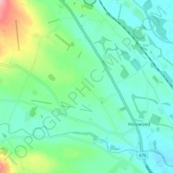
Nom : Carte topographique Holywood, altitude, relief.
Altitude moyenne : 26 m
Altitude minimum : 7 m
Altitude maximum : 62 m
Autres cartes topographiques
Cliquez sur une carte pour visualiser sa topographie, son altitude et son relief.
Sanquhar
United Kingdom > Scotland > Dumfries and Galloway
Sanquhar, Dumfries and Galloway, Scotland, DG4 6DJ, United Kingdom
Altitude moyenne : 243 m
Gillesbie
United Kingdom > Scotland > Dumfries and Galloway > Boreland
Gillesbie, Boreland, Dumfries and Galloway, Scotland, DG11 2LF, United Kingdom
Altitude moyenne : 195 m
Lockerbie
United Kingdom > Scotland > Dumfries and Galloway
Lockerbie, Dumfries and Galloway, Scotland, DG11 2EU, United Kingdom
Altitude moyenne : 96 m
Ley Hill
United Kingdom > Scotland > Dumfries and Galloway
Ley Hill, Dumfries and Galloway, Scotland, DG11 3HG, United Kingdom
Altitude moyenne : 214 m
Cairnryan
United Kingdom > Scotland > Dumfries and Galloway > Cairnryan
Cairnryan, Dumfries and Galloway, Scotland, DG9 8RB, United Kingdom
Altitude moyenne : 64 m
Drummore
United Kingdom > Scotland > Dumfries and Galloway
Drummore, Dumfries and Galloway, Scotland, DG9 9PY, United Kingdom
Altitude moyenne : 36 m