
Carte topographique Cabra Island
Carte interactive
Cliquez sur la carte pour afficher l’altitude.
Cabra Island
With a length of about 4.5 km (2.8 miles) and about 2.9 km (1.8 miles) at its widest, the island has a flat terrain with the highest elevation at 60.96 metres (around 200 feet). A particular rock islet near one beach is considered by locals as a symbol of the island given its shape as a cabra (Spanish for “goat”). The Cabra Island Lighthouse complex is located on Cabra Island.
À propos de cette carte
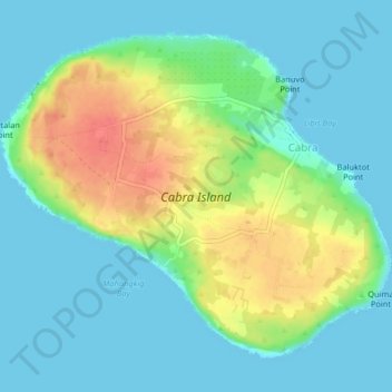
Nom : Carte topographique Cabra Island, altitude, relief.
Altitude moyenne : 17 m
Altitude minimum : -1 m
Altitude maximum : 56 m
Autres cartes topographiques
Cliquez sur une carte pour visualiser sa topographie, son altitude et son relief.