
Carte topographique Žilina
Carte interactive
Cliquez sur la carte pour afficher l’altitude.
À propos de cette carte
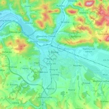
Nom : Carte topographique Žilina, altitude, relief.
Altitude moyenne : 424 m
Altitude minimum : 314 m
Altitude maximum : 792 m
Žilina lies at an altitude of 342 metres (1,122 ft) above sea level and covers an area of 80.03 square kilometres (30.9 sq mi). It is located in the Upper Váh region (Slovak: Horné Považie) at the confluence of three rivers: Váh, flowing from the east into the south-west, Kysuca, flowing from the north and Rajčanka rivers from the south, in the Žilina Basin. The city is surrounded by these mountain ranges: Malá Fatra, Súľovské vrchy, Javorníky and Kysucká vrchovina. Protected areas nearby include the Strážov Mountains Protected Landscape Area, the Kysuce Protected Landscape Area, and the Malá Fatra National Park. There are two hydroelectric dams on the Váh river around Žilina: the Žilina dam in the east and the Hričov dam in the west.