
Carte topographique Westerbroek
Carte interactive
Cliquez sur la carte pour afficher l’altitude.
À propos de cette carte
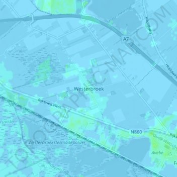
Nom : Carte topographique Westerbroek, altitude, relief.
Lieu : Westerbroek, Groningen, Nederland, 9608, Nederland (53.16403 6.66626 53.20403 6.70626)
Altitude moyenne : 0 m
Altitude minimum : -10 m
Altitude maximum : 8 m
Autres cartes topographiques
Cliquez sur une carte pour visualiser sa topographie, son altitude et son relief.
Foxholsterbosch
Nederland > Groningen > Westerbroek
Foxholsterbosch, Westerbroek, Midden-Groningen, Groningen, Nederland, 9608 PD, Nederland
Altitude moyenne : 0 m