Géolocaliser

Carte topographique Kodagu

Carte interactive

Cliquez sur la carte pour afficher l’altitude.

À propos de cette carte

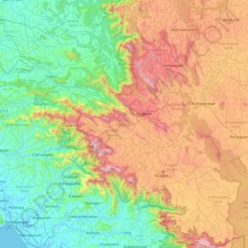
Nom : Carte topographique Kodagu, altitude, relief.

Lieu : Kodagu, Karnataka, India (11.93123 75.36544 12.83349 76.18857)

Altitude moyenne : 561 m

Altitude minimum : -3 m

Altitude maximum : 1 713 m

Kodagu is located on the eastern slopes of the Western Ghats. It has a geographical area of 4,102 km2 (1,584 sq mi). The district is bordered by Dakshina Kannada district to the northwest, Hassan district to the north, Mysore district to the east, Kasaragod district in west and Kannur district of Kerala to the southwest, and Wayanad district of Kerala to the south. It is a hilly district, the lowest elevation of which is 120 metres (390 ft) above sea-level. The highest peak, Tadiandamol, rises to 1,750 metres (5,740 ft), with Pushpagiri, the second highest, at 1,715 metres (5,627 ft). The main river in Kodagu is the Kaveri (Cauvery), which originates at Talakaveri, located on the eastern side of the Western Ghats, and with its tributaries, drains the greater part of Kodagu.

Autres cartes topographiques

Cliquez sur une carte pour visualiser sa topographie, son altitude et son relief.

Vidyaranyapura

India > Karnataka > Yelahanka taluku > Bengaluru

Vidyaranyapura, Yelahanka Zone, Bengaluru, Yelahanka taluku, Bengaluru Urban District, Karnataka, 560097, India

Altitude moyenne : 920 m

Vidyaranyapura

India > Karnataka > Sringeri taluku

Vidyaranyapura, Sringeri taluku, Chikkamagaluru District, Karnataka, 577592, India

Altitude moyenne : 654 m

Vaderahalli

India > Karnataka > Chikkanayakanahalli taluk

Vaderahalli, Chikkanayakanahalli taluk, Tumakuru District, Karnataka, 572214, India

Altitude moyenne : 784 m

Hubballi

India > Karnataka > Hubballi

Hubballi, Hubballi taluku, Dharwad district, Karnataka, 580020, India

Altitude moyenne : 626 m

Siddapura

India > Karnataka > Siddapura

Siddapura, Beluru taluk, Hassan district, Karnataka, 573121, India

Altitude moyenne : 898 m

Kamalapura

India > Karnataka > Kamalapura

Kamalapura, Hosapete taluk, Bellary district, Karnataka, 583221, India

Altitude moyenne : 456 m

Krishna River

India > Karnataka

Krishna River, Shahapura taluku, Yadagiri district, Karnataka, 412803, India

Altitude moyenne : 413 m

Tadiandamol

India > Karnataka

Tadiandamol, Madikeri taluku, Kodagu, Karnataka, India

Altitude moyenne : 1 322 m

Bandala

India > Karnataka > Bandala

Bandala, Sindagi taluku, Bijapur district, Karnataka, 128, India

Altitude moyenne : 498 m

Hegganahalli

India > Karnataka > Bengaluru

Hegganahalli, Dasarahalli Zone, Bengaluru, Bangalore Urban, Karnataka, India

Altitude moyenne : 907 m

Baba Budangiri

India > Karnataka > Chikkamagaluru

Baba Budangiri, Chikkamagaluru, Chikkamagaluru taluku, Chikkamagaluru district, Karnataka, 577101, India

Altitude moyenne : 1 628 m

Kodagu

India > Karnataka

Kodagu, Karnataka, India

Altitude moyenne : 521 m

Chikmagalur

India > Karnataka

Chikmagalur, Chikkamagaluru district, Karnataka, India

Altitude moyenne : 652 m

Sampangiram Nagar Ward

India > Karnataka > Bengaluru

Sampangiram Nagar Ward, East Zone, Bengaluru, Bangalore Urban, Karnataka, India

Altitude moyenne : 916 m

Bangalore Urban

India > Karnataka

Bangalore Urban, Karnataka, India

Altitude moyenne : 856 m

Kumara Parvatha

India > Karnataka

Kumara Parvatha, Somawarpet taluk, Kodagu, Karnataka, India

Altitude moyenne : 1 227 m