Géolocaliser
👉 Easily get elevation data in JSON, GeoTIFF and KML formats using Elevation API
Merci de soutenir ce site ❤️
Faire un don

Carte topographique Kanpur

Cliquez sur la carte pour afficher l’altitude.

Kanpur

Situated in the flat Indo-Gangetic Plains, Kanpur has an average elevation of 318 metres (1,043 ft) above sea level. The Ganga flows by the city and several ghats are located on its banks, notably the Sati Chaura Ghat and Sarsaiya Ghat. The Brahmavart Ghat located at Bithoor (25 km northwards) is another ghat of religious importance.

Wikipedia (CC-BY-SA 3.0)

À propos de cette carte

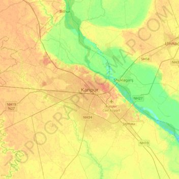
Nom : Carte topographique Kanpur, altitude, relief.

Lieu : Kanpur, Kanpur Nagar, Uttar Pradesh, 208012, India (26.30091 80.16176 26.62091 80.48176)

Altitude moyenne : 124 m

Altitude minimum : 105 m

Altitude maximum : 137 m

Équipez-vous pour votre prochaine aventure :

🔋Piles rechargeables - Énergie durable pour vos lampes et boussoles numériques
👕Sous-couche en laine mérinos - Régulation thermique naturelle pour les variations d'altitude
❄️Crampons antidérapants - Adhérence sur neige et glace
🧥Vestes polaires - Isolation thermique pour activités outdoor
🧤Gants de randonnée tactiles - Manipulez votre smartphone ou GPS sans geler vos mains

En tant que Partenaire Amazon, ce site perçoit une commission sur les achats éligibles sans surcoût pour vous.