
Carte topographique Sandanski
Carte interactive
Cliquez sur la carte pour afficher l’altitude.
À propos de cette carte
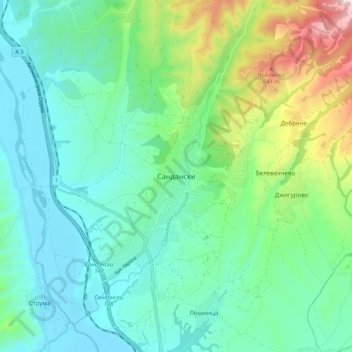
Nom : Carte topographique Sandanski, altitude, relief.
Lieu : Sandanski, Blagoevgrad, 2800, Bulgaria (41.52542 23.23864 41.60542 23.31864)
Altitude moyenne : 276 m
Altitude minimum : 97 m
Altitude maximum : 827 m
Sandanski has developed in an amphitheatrical fashion on the outer south-west flanks of Pirin Mountains along the lower reaches of Sandanska Bistritsa River. The town's altitude varies between 240 and 300 meters. Its geographical location between Kresna and Rupel Gorges determines town's mild winter temperatures. Statistically Sandanski has the warmest temperatures in Bulgaria with a total of around 2700 annual sunshine hours.
Autres cartes topographiques
Cliquez sur une carte pour visualiser sa topographie, son altitude et son relief.
Belasica
Belasica, Petrich, Blagoevgrad, 2880, Bulgaria
Altitude moyenne : 1 582 m
Tuhovishta
Tuhovishta, Satovcha, Blagoevgrad, 2939, Bulgaria
Altitude moyenne : 765 m
Алантепе
Алантепе, Belitsa, Blagoevgrad, 2785, Bulgaria
Altitude moyenne : 1 512 m
Goce Delcev
Goce Delcev, Gotse Delchev, Blagoevgrad, 2900, Bulgaria
Altitude moyenne : 705 m
Goreme
Bulgaria > Blagoevgrad > Goreme
Goreme, Strumiani, Blagoevgrad, 2834, Bulgaria
Altitude moyenne : 747 m