
Carte topographique Queenstown-Lakes District
Carte interactive
Cliquez sur la carte pour afficher l’altitude.
À propos de cette carte
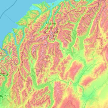
Nom : Carte topographique Queenstown-Lakes District, altitude, relief.
Lieu : Queenstown-Lakes District, Otago, New Zealand (-45.36757 168.11639 -43.95541 169.71978)
Altitude moyenne : 832 m
Altitude minimum : -1 m
Altitude maximum : 2 819 m
Autres cartes topographiques
Cliquez sur une carte pour visualiser sa topographie, son altitude et son relief.
Queenstown
New Zealand > Otago > Queenstown-Lakes District
Queenstown, Queenstown-Lakes District, Otago, 9348, New Zealand
Altitude moyenne : 592 m
Makarora River
New Zealand > Otago > Queenstown-Lakes District
Makarora River, Queenstown-Lakes District, Otago, 9346, New Zealand
Altitude moyenne : 1 081 m
Mount Pisa
New Zealand > Otago > Queenstown-Lakes District
Mount Pisa, Queenstown-Lakes District, Otago, New Zealand
Altitude moyenne : 1 739 m
Alexandra
New Zealand > Otago > Central Otago District > Vincent Community
Alexandra, Vincent Community, Central Otago District, Otago, 9320, New Zealand
Altitude moyenne : 241 m
Mount Pisa
New Zealand > Otago > Central Otago District > Cromwell Community
Mount Pisa, Cromwell Community, Central Otago District, Otago, 9383, New Zealand
Altitude moyenne : 230 m