
Carte topographique Mombasa
Carte interactive
Cliquez sur la carte pour afficher l’altitude.
À propos de cette carte
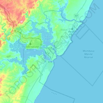
Nom : Carte topographique Mombasa, altitude, relief.
Lieu : Mombasa, Mvita, Mombasa County, Coastal Kenya, 80100, Kenya (-4.21052 39.50717 -3.89052 39.82717)
Altitude moyenne : 32 m
Altitude minimum : -3 m
Altitude maximum : 262 m
Being a coastal town, Mombasa is characterised by a flat topography. The town of Mombasa is centred on Mombasa Island, but extends to the mainland. The island is separated from the mainland by two creeks, Port Reitz in the south and Tudor Creek in the north.
Autres cartes topographiques
Cliquez sur une carte pour visualiser sa topographie, son altitude et son relief.
Tudor ward
Kenya > Mombasa County > Mvita > Tudor ward
Tudor ward, Mvita, Mombasa County, Coast, Kenya
Altitude moyenne : 15 m