Carte topographique Winterbourne
Carte interactive
Cliquez sur la carte pour afficher l’altitude.
À propos de cette carte
![Carte topographique Winterbourne, altitude, relief](/pub/maps/relation/xqb3/lqgh14/thumbnail.jpg)
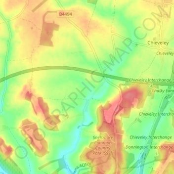
Nom : Carte topographique Winterbourne, altitude, relief.
Lieu : Winterbourne, West Berkshire, England, United Kingdom (51.43043 -1.36594 51.47305 -1.33106)
Altitude moyenne : 120 m
Altitude minimum : 86 m
Altitude maximum : 153 m
Autres cartes topographiques
Cliquez sur une carte pour visualiser sa topographie, son altitude et son relief.
![Carte topographique Berkshire, altitude, relief](/pub/maps/relation/8km2/85znh/icon.jpg)
Berkshire
United Kingdom > England > West Berkshire
Berkshire, West Berkshire, England, United Kingdom
Altitude moyenne : 100 m
![Carte topographique Reading, altitude, relief](/pub/maps/node/zt5k/kj17cz/icon.jpg)
Reading
United Kingdom > England > West Berkshire > Reading
Reading, West Berkshire, South East England, England, RG1 1DA, United Kingdom
Altitude moyenne : 56 m
![Carte topographique Curridge, altitude, relief](/pub/maps/node/krkl/dgfzpc3l/icon.jpg)
Curridge
United Kingdom > England > West Berkshire > Chieveley
Curridge, Chieveley, West Berkshire, England, RG18 9DY, United Kingdom
Altitude moyenne : 118 m
![Carte topographique Stratfield Mortimer, altitude, relief](/pub/maps/relation/h4mt/mx8hdn/icon.jpg)
Stratfield Mortimer
United Kingdom > England > West Berkshire
Stratfield Mortimer, West Berkshire, England, United Kingdom
Altitude moyenne : 68 m
![Carte topographique Enborne Row, altitude, relief](/pub/maps/node/9lt6/b84m2z4/icon.jpg)
Enborne Row
United Kingdom > England > West Berkshire
Enborne Row, West Berkshire, England, RG20 0PR, United Kingdom
Altitude moyenne : 112 m
![Carte topographique Westridge Green, altitude, relief](/pub/maps/node/smmt/w9tskn57/icon.jpg)
Westridge Green
United Kingdom > England > West Berkshire > Aldworth
Westridge Green, Aldworth, West Berkshire, England, RG8 9RF, United Kingdom
Altitude moyenne : 145 m
![Carte topographique Lambourn Woodlands, altitude, relief](/pub/maps/node/m5rr/r9qvpp18/icon.jpg)
Lambourn Woodlands
United Kingdom > England > West Berkshire > Lambourn
Lambourn Woodlands, Lambourn, West Berkshire, England, RG17 7BW, United Kingdom
Altitude moyenne : 188 m
![Carte topographique Ashmore Green, altitude, relief](/pub/maps/node/gt/6d1z163l/icon.jpg)
Ashmore Green
United Kingdom > England > West Berkshire > Cold Ash
Ashmore Green, Cold Ash, West Berkshire, England, RG18 9EX, United Kingdom
Altitude moyenne : 108 m
![Carte topographique Aldworth, altitude, relief](/pub/maps/relation/c25k/k2td3l/icon.jpg)
Aldworth
United Kingdom > England > West Berkshire
Aldworth, West Berkshire, England, United Kingdom
Altitude moyenne : 148 m
![Carte topographique Newbury, altitude, relief](/pub/maps/relation/84rr/35m2gp/icon.jpg)
Newbury
United Kingdom > England > West Berkshire
Newbury, West Berkshire, England, United Kingdom
Altitude moyenne : 97 m
![Carte topographique Compton, altitude, relief](/pub/maps/relation/7b3/3bcctp/icon.jpg)
Compton
United Kingdom > England > West Berkshire
Compton, West Berkshire, England, United Kingdom
Altitude moyenne : 137 m
![Carte topographique Brightwalton, altitude, relief](/pub/maps/relation/jc57/wtr3t6/icon.jpg)
Brightwalton
United Kingdom > England > West Berkshire
Brightwalton, West Berkshire, England, United Kingdom
Altitude moyenne : 178 m
![Carte topographique Catmore, altitude, relief](/pub/maps/relation/nv3q/72514s/icon.jpg)
Catmore
United Kingdom > England > West Berkshire
Catmore, West Berkshire, England, United Kingdom
Altitude moyenne : 182 m
![Carte topographique West Ilsley, altitude, relief](/pub/maps/relation/369m/dc7218/icon.jpg)
West Ilsley
United Kingdom > England > West Berkshire
West Ilsley, West Berkshire, England, United Kingdom
Altitude moyenne : 161 m
![Carte topographique East Ilsley, altitude, relief](/pub/maps/relation/drgt/8bm7mt/icon.jpg)
East Ilsley
United Kingdom > England > West Berkshire
East Ilsley, West Berkshire, England, United Kingdom
Altitude moyenne : 148 m
![Carte topographique Peasemore, altitude, relief](/pub/maps/relation/4hm2/lqxzz4/icon.jpg)
Peasemore
United Kingdom > England > West Berkshire
Peasemore, West Berkshire, England, United Kingdom
Altitude moyenne : 155 m
![Carte topographique Beedon, altitude, relief](/pub/maps/relation/8l14/k1xvkl/icon.jpg)
Beedon
United Kingdom > England > West Berkshire
Beedon, West Berkshire, England, United Kingdom
Altitude moyenne : 160 m
![Carte topographique Ufton Nervet, altitude, relief](/pub/maps/relation/6m4s/krnh3l/icon.jpg)
Ufton Nervet
United Kingdom > England > West Berkshire
Ufton Nervet, West Berkshire, England, United Kingdom
Altitude moyenne : 81 m
![Carte topographique Stanford Dingley, altitude, relief](/pub/maps/relation/5rtf/hkcf51/icon.jpg)
Stanford Dingley
United Kingdom > England > West Berkshire
Stanford Dingley, West Berkshire, England, United Kingdom
Altitude moyenne : 83 m
![Carte topographique Purley on Thames, altitude, relief](/pub/maps/relation/kp14/btwx5k/icon.jpg)
Purley on Thames
United Kingdom > England > West Berkshire
Purley on Thames, West Berkshire, England, United Kingdom
Altitude moyenne : 57 m
![Carte topographique Sheepdrove, altitude, relief](/pub/maps/node/l9b3/4bgtjcgt/icon.jpg)
Sheepdrove
United Kingdom > England > West Berkshire > Lambourn
Sheepdrove, Lambourn, West Berkshire, England, RG17 7UT, United Kingdom
Altitude moyenne : 167 m
![Carte topographique Streatley, altitude, relief](/pub/maps/relation/xm3l/s5lq1h/icon.jpg)
Streatley
United Kingdom > England > West Berkshire
Streatley, West Berkshire, England, United Kingdom
Altitude moyenne : 95 m
![Carte topographique Boxford, altitude, relief](/pub/maps/relation/g13l/2f3ctj/icon.jpg)
Boxford
United Kingdom > England > West Berkshire
Boxford, West Berkshire, England, United Kingdom
Altitude moyenne : 123 m
![Carte topographique Aldermaston, altitude, relief](/pub/maps/relation/qx57/2swjtj/icon.jpg)
Aldermaston
United Kingdom > England > West Berkshire
Aldermaston, West Berkshire, England, United Kingdom
Altitude moyenne : 82 m
![Carte topographique Hungerford, altitude, relief](/pub/maps/relation/x75k/6r1xb3/icon.jpg)
Hungerford
United Kingdom > England > West Berkshire
Hungerford, West Berkshire, England, United Kingdom
Altitude moyenne : 131 m
![Carte topographique Hyde End, altitude, relief](/pub/maps/node/lg4s/qnzfvr5k/icon.jpg)
Hyde End
United Kingdom > England > West Berkshire > Brimpton
Hyde End, Brimpton, West Berkshire, England, RG7 4RJ, United Kingdom
Altitude moyenne : 83 m
![Carte topographique Donnington Castle, altitude, relief](/pub/maps/way/knx/tdtnz5k/icon.jpg)
Donnington Castle
United Kingdom > England > West Berkshire > Speen
Donnington Castle, Shop Lane, Shaw cum Donnington, Speen, West Berkshire, England, RG14 2JT, United Kingdom
Altitude moyenne : 100 m
![Carte topographique World's End, altitude, relief](/pub/maps/node/6f3/mbf2qfgp/icon.jpg)
World's End
United Kingdom > England > West Berkshire
World's End, Beedon, West Berkshire, England, RG20 8SF, United Kingdom
Altitude moyenne : 145 m
![Carte topographique Pangbourne, altitude, relief](/pub/maps/relation/4qcz/jhbgnx/icon.jpg)
Pangbourne
United Kingdom > England > West Berkshire
Pangbourne, West Berkshire, England, United Kingdom
Altitude moyenne : 64 m
![Carte topographique Chapel Row, altitude, relief](/pub/maps/node/hhgp/m6ck8lnh/icon.jpg)
Chapel Row
United Kingdom > England > West Berkshire
Chapel Row, Bucklebury, West Berkshire, England, RG7 6PD, United Kingdom
Altitude moyenne : 96 m
![Carte topographique Aldermaston Wharf, altitude, relief](/pub/maps/node/bqkl/l3ctsm2/icon.jpg)
Aldermaston Wharf
United Kingdom > England > West Berkshire > Aldermaston Wharf
Aldermaston Wharf, West Berkshire, England, RG7 4SF, United Kingdom
Altitude moyenne : 69 m
![Carte topographique Chieveley, altitude, relief](/pub/maps/relation/qft6/k17ckl/icon.jpg)
Chieveley
United Kingdom > England > West Berkshire
Chieveley, West Berkshire, England, United Kingdom
Altitude moyenne : 123 m
![Carte topographique Chaddleworth, altitude, relief](/pub/maps/relation/7514/k1cfkl/icon.jpg)
Chaddleworth
United Kingdom > England > West Berkshire > Chaddleworth
Chaddleworth, West Berkshire, England, United Kingdom
Altitude moyenne : 164 m
![Carte topographique Inkpen, altitude, relief](/pub/maps/relation/sg9m/35qrgp/icon.jpg)
Inkpen
United Kingdom > England > West Berkshire
Inkpen, West Berkshire, England, United Kingdom
Altitude moyenne : 160 m
![Carte topographique Hermitage, altitude, relief](/pub/maps/relation/t9cz/8bplgt/icon.jpg)
Hermitage
United Kingdom > England > West Berkshire
Hermitage, West Berkshire, England, United Kingdom
Altitude moyenne : 119 m
![Carte topographique Upper Basildon, altitude, relief](/pub/maps/node/qgnx/k917l51/icon.jpg)
Upper Basildon
United Kingdom > England > West Berkshire
Upper Basildon, West Berkshire, England, RG8 8LS, United Kingdom
Altitude moyenne : 103 m
![Carte topographique Thatcham, altitude, relief](/pub/maps/relation/5357/lqmk14/icon.jpg)
Thatcham
United Kingdom > England > West Berkshire > Thatcham
Thatcham, West Berkshire, England, United Kingdom
Altitude moyenne : 94 m
![Carte topographique Kintbury, altitude, relief](/pub/maps/relation/fl9m/35cxgp/icon.jpg)
Kintbury
United Kingdom > England > West Berkshire
Kintbury, West Berkshire, England, United Kingdom
Altitude moyenne : 121 m
![Carte topographique Lambourn, altitude, relief](/pub/maps/relation/fl3l/8bb6mt/icon.jpg)
Lambourn
United Kingdom > England > West Berkshire
Lambourn, West Berkshire, England, United Kingdom
Altitude moyenne : 177 m
![Carte topographique West Woodhay, altitude, relief](/pub/maps/relation/k9b3/wt3tt6/icon.jpg)
West Woodhay
United Kingdom > England > West Berkshire
West Woodhay, West Berkshire, England, United Kingdom
Altitude moyenne : 158 m
![Carte topographique Beenham, altitude, relief](/pub/maps/relation/gf3l/t65crr/icon.jpg)
Beenham
United Kingdom > England > West Berkshire > Beenham
Beenham, West Berkshire, England, United Kingdom
Altitude moyenne : 77 m
![Carte topographique Enborne, altitude, relief](/pub/maps/relation/dtmt/72zjzs/icon.jpg)
Enborne
United Kingdom > England > West Berkshire
Enborne, West Berkshire, South East England, England, United Kingdom
Altitude moyenne : 104 m
![Carte topographique Welford, altitude, relief](/pub/maps/relation/f6nh/6rp1f3/icon.jpg)
Welford
United Kingdom > England > West Berkshire
Welford, West Berkshire, England, United Kingdom
Altitude moyenne : 124 m
![Carte topographique Greenham, altitude, relief](/pub/maps/relation/w5zs/dcl8s8/icon.jpg)
Greenham
United Kingdom > England > West Berkshire
Greenham, West Berkshire, England, United Kingdom
Altitude moyenne : 94 m
![Carte topographique Ashampstead, altitude, relief](/pub/maps/relation/77nh/wn47t6/icon.jpg)
Ashampstead
United Kingdom > England > West Berkshire
Ashampstead, West Berkshire, South East England, England, United Kingdom
Altitude moyenne : 123 m
![Carte topographique Cold Ash, altitude, relief](/pub/maps/relation/wn3l/1dct3q/icon.jpg)
Cold Ash
United Kingdom > England > West Berkshire
Cold Ash, West Berkshire, England, United Kingdom
Altitude moyenne : 115 m
![Carte topographique Midgham, altitude, relief](/pub/maps/relation/zdnx/fqdz9m/icon.jpg)
Midgham
United Kingdom > England > West Berkshire
Midgham, West Berkshire, England, United Kingdom
Altitude moyenne : 90 m
![Carte topographique Bradfield Southend, altitude, relief](/pub/maps/node/4ttp/b7n1114/icon.jpg)
Bradfield Southend
United Kingdom > England > West Berkshire > Bradfield Southend
Bradfield Southend, West Berkshire, South East England, England, RG7 6HJ, United Kingdom
Altitude moyenne : 80 m
![Carte topographique Kintbury Gate, altitude, relief](/pub/maps/node/f8gt/33g7p18/icon.jpg)
Kintbury Gate
United Kingdom > England > West Berkshire > Hungerford
Kintbury Gate, Hungerford, West Berkshire, South East England, England, RG17 0UU, United Kingdom
Altitude moyenne : 110 m
![Carte topographique Great Shefford, altitude, relief](/pub/maps/relation/9gzs/dct218/icon.jpg)
Great Shefford
United Kingdom > England > West Berkshire
Great Shefford, West Berkshire, England, United Kingdom
Altitude moyenne : 148 m