
Faire un don
Équipez-vous pour votre prochaine aventure :
En tant que Partenaire Amazon, ce site perçoit une commission sur les achats éligibles sans surcoût pour vous.
Carte topographique Colonia Fabricii
Cliquez sur la carte pour afficher l’altitude.
Faire un don
Équipez-vous pour votre prochaine aventure :
En tant que Partenaire Amazon, ce site perçoit une commission sur les achats éligibles sans surcoût pour vous.
À propos de cette carte
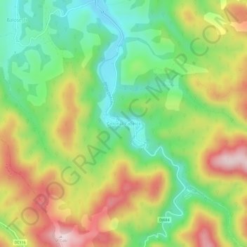
Nom : Carte topographique Colonia Fabricii, altitude, relief.
Lieu : Colonia Fabricii, Tomești, Timiș, 307412, Romania (45.74553 22.29452 45.78553 22.33452)
Altitude moyenne : 405 m
Altitude minimum : 235 m
Altitude maximum : 629 m
Faire un don
Équipez-vous pour votre prochaine aventure :
En tant que Partenaire Amazon, ce site perçoit une commission sur les achats éligibles sans surcoût pour vous.
Autres cartes topographiques
Cliquez sur une carte pour visualiser sa topographie, son altitude et son relief.
Timișoara
Timișoara lies at an altitude of 90 metres on the southeast edge of the Banat Plain, part of the Pannonian Plain, near the divergence of the Timiș and Bega rivers. The waters of the two rivers form a swampy and frequently flooded land. Timișoara developed on one of few places where the swamps could be…
Altitude moyenne : 92 m
Sannicolau Mare
The territory is located in the Mureș Plain, which is a typical form of fluvio-lacustrine subsidence, with shallow valleys with abandoned riverbeds resulting from the regularization of watercourses and drainage, with an altitude between 80–85 m (262–279 ft). The northern part is located in the former…
Altitude moyenne : 85 m
Faire un don
Équipez-vous pour votre prochaine aventure :
En tant que Partenaire Amazon, ce site perçoit une commission sur les achats éligibles sans surcoût pour vous.
Timișoara
Timișoara lies at an altitude of 90 metres on the southeast edge of the Banat Plain, part of the Pannonian Plain, near the divergence of the Timiș and Bega rivers. The waters of the two rivers form a swampy and frequently flooded land. Timișoara developed on one of few places where the swamps could be…
Altitude moyenne : 92 m
Faire un don
Équipez-vous pour votre prochaine aventure :
En tant que Partenaire Amazon, ce site perçoit une commission sur les achats éligibles sans surcoût pour vous.
Faire un don
Équipez-vous pour votre prochaine aventure :
En tant que Partenaire Amazon, ce site perçoit une commission sur les achats éligibles sans surcoût pour vous.
Faire un don
Équipez-vous pour votre prochaine aventure :
En tant que Partenaire Amazon, ce site perçoit une commission sur les achats éligibles sans surcoût pour vous.
Lugoj
The territory of Lugoj belongs to the high plain of Lugoj and the hills of Lugoj. Located in the contact area of these units, the city developed on the lower terrace of the Timiș River, on both its banks. The relief unit in which Lugoj is located is the Lugoj Plain, which penetrates deep into the piedmont…
Altitude moyenne : 145 m
Jimbolia
Jimbolia is located in the west of Timiș County, 39 km from Timișoara, with which it is connected by the county road 59A and the Kikinda–Jimbolia–Timișoara railway. It lies in the Banat Plain, at the contact between the Timiș Plain and the Mureș Plain. An alignment of villages marks the boundary…
Altitude moyenne : 80 m
Faire un don
Équipez-vous pour votre prochaine aventure :
En tant que Partenaire Amazon, ce site perçoit une commission sur les achats éligibles sans surcoût pour vous.
Timișoara
Timișoara lies at an altitude of 90 metres on the southeast edge of the Banat Plain, part of the Pannonian Plain, near the divergence of the Timiș and Bega rivers. The waters of the two rivers form a swampy and frequently flooded land. Timișoara developed on one of few places where the swamps could be…
Altitude moyenne : 92 m
Faire un don
Équipez-vous pour votre prochaine aventure :
En tant que Partenaire Amazon, ce site perçoit une commission sur les achats éligibles sans surcoût pour vous.