
Carte topographique Fairfield Township
Carte interactive
Cliquez sur la carte pour afficher l’altitude.
À propos de cette carte
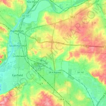
Nom : Carte topographique Fairfield Township, altitude, relief.
Lieu : Fairfield Township, Butler County, Ohio, United States (39.30853 -84.63139 39.43692 -84.47446)
Altitude moyenne : 207 m
Altitude minimum : 164 m
Altitude maximum : 276 m
Fairfield Township's name is reflective of the gentle topography in the township. It is one of seven Fairfield Townships statewide.
Autres cartes topographiques
Cliquez sur une carte pour visualiser sa topographie, son altitude et son relief.
Cleveland
United States > Ohio > Cuyahoga County > Cleveland
Cleveland, Cuyahoga County, Ohio, 44113, United States
Altitude moyenne : 221 m
Black Hand Gorge State Nature Preserve
United States > Ohio > Licking County
Black Hand Gorge State Nature Preserve, Stoney Hill Road Southeast, Hanover Township, Licking County, Ohio, United States
Altitude moyenne : 273 m