
Carte topographique Lieving
Carte interactive
Cliquez sur la carte pour afficher l’altitude.
À propos de cette carte
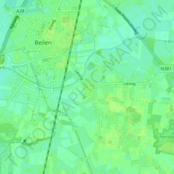
Nom : Carte topographique Lieving, altitude, relief.
Altitude moyenne : 15 m
Altitude minimum : 9 m
Altitude maximum : 19 m
Autres cartes topographiques
Cliquez sur une carte pour visualiser sa topographie, son altitude et son relief.
Brunstinger leek
Nederland > Drenthe > Beilen > Brunsting
Brunstinger leek, Brunsting, Beilen, Midden-Drenthe, Drenthe, Nederland, 9411, Nederland
Altitude moyenne : 13 m