
Carte topographique Wansfell Pike
Cliquez sur la carte pour afficher l’altitude.
Wansfell Pike
Wansfell has an extensive summit ridge with two tops. The highest point of the fell is called Baystones with a height of 488 m (1,601 ft), while Wansfell Pike, which lies a kilometre to the south west reaches an elevation of 482 m (1,581 ft). Of the two summits, Wansfell Pike is regarded as the “true” summit of the fell by many fell walkers because of its superior view, even though it is the lower of the pair.
À propos de cette carte
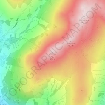
Nom : Carte topographique Wansfell Pike, altitude, relief.
Altitude moyenne : 285 m
Altitude minimum : 53 m
Altitude maximum : 484 m
Autres cartes topographiques
Cliquez sur une carte pour visualiser sa topographie, son altitude et son relief.