
Carte topographique Teresa
Carte interactive
Cliquez sur la carte pour afficher l’altitude.
À propos de cette carte
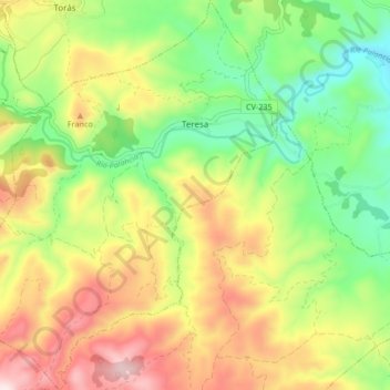
Nom : Carte topographique Teresa, altitude, relief.
Altitude moyenne : 752 m
Altitude minimum : 524 m
Altitude maximum : 1 047 m
Autres cartes topographiques
Cliquez sur une carte pour visualiser sa topographie, son altitude et son relief.
Penyagolosa
Spain > Valencian Community > Castelló / Castellón > Xodos / Chodos
Penyagolosa, Xodos / Chodos, l'Alcalatén, Castelló / Castellón, Valencian Community, Spain
Altitude moyenne : 1 417 m