
Carte topographique Paternion
Carte interactive
Cliquez sur la carte pour afficher l’altitude.
À propos de cette carte
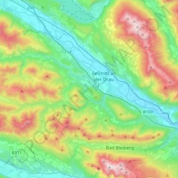
Nom : Carte topographique Paternion, altitude, relief.
Lieu : Paternion, Bezirk Villach-Land, Karinthië, 9711, Oostenrijk (46.63610 13.42998 46.74311 13.71700)
Altitude moyenne : 1 003 m
Altitude minimum : 495 m
Altitude maximum : 2 152 m
Autres cartes topographiques
Cliquez sur une carte pour visualiser sa topographie, son altitude et son relief.
Kerna
Oostenrijk > Karinthië > Bezirk Villach-Land > Velden am Wörther See
Kerna, Velden am Wörther See, Bezirk Villach-Land, Karinthië, 9536, Oostenrijk
Altitude moyenne : 529 m
Annenheim
Oostenrijk > Karinthië > Bezirk Villach-Land
Annenheim, Treffen am Ossiacher See, Bezirk Villach-Land, Karinthië, 9521, Oostenrijk
Altitude moyenne : 787 m
Bach
Oostenrijk > Karinthië > Bezirk Villach-Land > Velden am Wörther See > Lamp
Bach, Lamp, Velden am Wörther See, Bezirk Villach-Land, Karinthië, 9232, Oostenrijk
Altitude moyenne : 539 m
Faaker See
Oostenrijk > Karinthië > Bezirk Villach-Land > Finkenstein am Faaker See > Faak am See
Faaker See, Faak am See, Finkenstein am Faaker See, Bezirk Villach-Land, Karinthië, 9584, Oostenrijk
Altitude moyenne : 572 m
Arnoldstein
Oostenrijk > Karinthië > Bezirk Villach-Land > Arnoldstein
Arnoldstein, Bezirk Villach-Land, Karinthië, Oostenrijk
Altitude moyenne : 935 m
Treffen/Trebinja
Oostenrijk > Karinthië > Bezirk Villach-Land > Velden am Wörther See > Treffen/Trebinja
Treffen/Trebinja, Velden am Wörther See, Bezirk Villach-Land, Karinthië, 9536, Oostenrijk
Altitude moyenne : 524 m
Gerlitzen
Oostenrijk > Karinthië > Bezirk Villach-Land > Arriach
Gerlitzen, Arriach, Bezirk Villach-Land, Karinthië, 9543, Oostenrijk
Altitude moyenne : 1 631 m
Winklern
Oostenrijk > Karinthië > Bezirk Villach-Land > Äußere Einöde > Winklern
Winklern, Äußere Einöde, Treffen am Ossiacher See, Bezirk Villach-Land, Karinthië, 9521, Oostenrijk
Altitude moyenne : 870 m
Pölling
Oostenrijk > Karinthië > Bezirk Villach-Land > Treffen am Ossiacher See > Pölling
Pölling, Treffen am Ossiacher See, Bezirk Villach-Land, Karinthië, 9521, Oostenrijk
Altitude moyenne : 1 079 m
Kerschdorf
Oostenrijk > Karinthië > Bezirk Villach-Land > Nötsch im Gailtal > Kerschdorf
Kerschdorf, Nötsch im Gailtal, Bezirk Villach-Land, Karinthië, 9612, Oostenrijk
Altitude moyenne : 884 m
Deutschberg
Oostenrijk > Karinthië > Bezirk Villach-Land > Sattendorf > Deutschberg
Deutschberg, Sattendorf, Treffen am Ossiacher See, Bezirk Villach-Land, Karinthië, 9521, Oostenrijk
Altitude moyenne : 930 m
Latschach
Oostenrijk > Karinthië > Bezirk Villach-Land > Finkenstein am Faaker See > Ratnitz > Latschach
Latschach, Ratnitz, Finkenstein am Faaker See, Bezirk Villach-Land, Karinthië, 9584, Oostenrijk
Altitude moyenne : 673 m
Nötsch im Gailtal
Oostenrijk > Karinthië > Bezirk Villach-Land > Nötsch im Gailtal
Nötsch im Gailtal, Bezirk Villach-Land, Karinthië, Oostenrijk
Altitude moyenne : 966 m