
Carte topographique Schwarzenbach
Carte interactive
Cliquez sur la carte pour afficher l’altitude.
À propos de cette carte
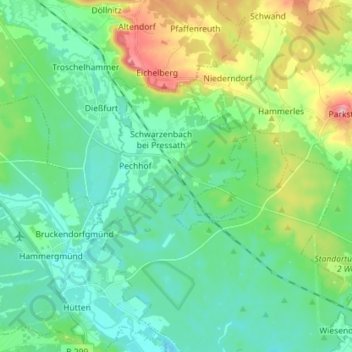
Nom : Carte topographique Schwarzenbach, altitude, relief.
Altitude moyenne : 436 m
Altitude minimum : 390 m
Altitude maximum : 572 m
Autres cartes topographiques
Cliquez sur une carte pour visualiser sa topographie, son altitude et son relief.
Hofstatt
Deutschland > Bayern > Landkreis Neustadt an der Waldnaab > Floß
Hofstatt, Floß, Landkreis Neustadt an der Waldnaab, Bayern, 92685, Deutschland
Altitude moyenne : 526 m