
Carte topographique Houghton
Carte interactive
Cliquez sur la carte pour afficher l’altitude.
À propos de cette carte
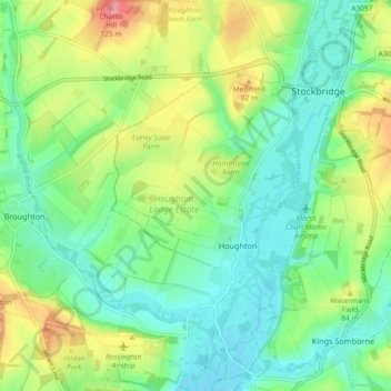
Nom : Carte topographique Houghton, altitude, relief.
Altitude moyenne : 61 m
Altitude minimum : 25 m
Altitude maximum : 131 m
Autres cartes topographiques
Cliquez sur une carte pour visualiser sa topographie, son altitude et son relief.
Redenham
United Kingdom > England > Test Valley > Redenham
Redenham, Test Valley, Hampshire, South East, England, SP11 9AY, United Kingdom
Altitude moyenne : 113 m
Romsey and Southampton North
United Kingdom > England > Test Valley
Romsey and Southampton North, Bossington, Test Valley, Hampshire, South East, England, United Kingdom
Altitude moyenne : 75 m
Kimpton
United Kingdom > England > Test Valley
Kimpton, Test Valley, Hampshire, South East, England, United Kingdom
Altitude moyenne : 111 m
Toot Hill
United Kingdom > England > Test Valley
Toot Hill, Test Valley, Hampshire, South East, England, SO16 8AL, United Kingdom
Altitude moyenne : 45 m
Michelmersh and Timsbury
United Kingdom > England > Test Valley
Michelmersh and Timsbury, Test Valley, Hampshire, South East, England, United Kingdom
Altitude moyenne : 46 m
River Dever
United Kingdom > England > Test Valley
River Dever, Test Valley, Hampshire, South East, England, SO21 3QG, United Kingdom
Altitude moyenne : 74 m
Nursling and Rownhams
United Kingdom > England > Test Valley
Nursling and Rownhams, Test Valley, Hampshire, South East, England, United Kingdom
Altitude moyenne : 31 m
Valley Park
United Kingdom > England > Test Valley
Valley Park, Test Valley, Hampshire, South East, England, United Kingdom
Altitude moyenne : 37 m