
Faire un don
Équipez-vous pour votre prochaine aventure :
En tant que Partenaire Amazon, ce site perçoit une commission sur les achats éligibles sans surcoût pour vous.
Carte topographique Hampstead
Cliquez sur la carte pour afficher l’altitude.
Faire un don
Équipez-vous pour votre prochaine aventure :
En tant que Partenaire Amazon, ce site perçoit une commission sur les achats éligibles sans surcoût pour vous.
Hampstead
The Town of Hampstead was founded in 1914. It was designed to be an exclusive garden city. There are no retail shops within municipal boundaries. Houses were assigned relatively large lots to allow space for trees and shrubbery. The town's roads were designed with curves in order to slow down traffic and to create an interesting and intimate landscape. Despite its rather flat topography—much of the territory was once a golf course—the town was named after another garden city, the London suburb of Hampstead Village. Like its namesake, Hampstead is the home of many affluent citizens, and competes with a few other suburbs for first place in the rankings of highest average household incomes in Canada.
Faire un don
Équipez-vous pour votre prochaine aventure :
En tant que Partenaire Amazon, ce site perçoit une commission sur les achats éligibles sans surcoût pour vous.
À propos de cette carte
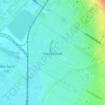
Nom : Carte topographique Hampstead, altitude, relief.
Altitude moyenne : 57 m
Altitude minimum : 47 m
Altitude maximum : 95 m
Faire un don
Équipez-vous pour votre prochaine aventure :
En tant que Partenaire Amazon, ce site perçoit une commission sur les achats éligibles sans surcoût pour vous.
Autres cartes topographiques
Cliquez sur une carte pour visualiser sa topographie, son altitude et son relief.
Mount Royal
Canada > Quebec > Urban agglomeration of Montreal > Montreal
The hill is part of the Monteregian Hills situated between the Laurentians and the Appalachian Mountains. It gave its Latin name, Mons Regius, to the Monteregian chain. The hill consists of three peaks: Colline de la Croix (or Mont Royal proper) at 233 m (764 ft), Colline d'Outremont (or Mount Murray, in the…
Altitude moyenne : 111 m
Parc Léon-Provancher
Canada > Quebec > Urban agglomeration of Montreal > Montreal
Altitude moyenne : 53 m
Faire un don
Équipez-vous pour votre prochaine aventure :
En tant que Partenaire Amazon, ce site perçoit une commission sur les achats éligibles sans surcoût pour vous.
Saint Helen's Island
Canada > Quebec > Urban agglomeration of Montreal > Montreal
Altitude moyenne : 15 m
Parc-nature du Bois-de-Liesse
Canada > Quebec > Urban agglomeration of Montreal > Montreal
Altitude moyenne : 28 m
Banc de Châteauguay
Canada > Quebec > Urban agglomeration of Montreal > Dorval
Altitude moyenne : 20 m
Faire un don
Équipez-vous pour votre prochaine aventure :
En tant que Partenaire Amazon, ce site perçoit une commission sur les achats éligibles sans surcoût pour vous.
Mount Royal Park
Canada > Quebec > Urban agglomeration of Montreal > Montreal
The mountain is part of the Monteregian Hills situated between the Laurentians and the Appalachian Mountains. It gave its Latin name, Mons Regius, to the Monteregian chain. The mountain consists of three peaks: Colline de la Croix (or Mont Royal proper) at 233 m (764 ft), Colline d'Outremont (or Mount Murray,…
Altitude moyenne : 110 m
Cap Saint-Jacques
Canada > Quebec > Urban agglomeration of Montreal > Montreal
Altitude moyenne : 25 m
Faire un don
Équipez-vous pour votre prochaine aventure :
En tant que Partenaire Amazon, ce site perçoit une commission sur les achats éligibles sans surcoût pour vous.
Mount Royal
Canada > Quebec > Urban agglomeration of Montreal > Montreal
The mountain is part of the Monteregian Hills situated between the Laurentians and the Appalachian Mountains. It gave its Latin name, Mons Regius, to the Monteregian chain. The mountain consists of three peaks: Colline de la Croix (or Mont Royal proper) at 233 m (764 ft), Colline d'Outremont (or Mount Murray,…
Altitude moyenne : 111 m
Faire un don
Équipez-vous pour votre prochaine aventure :
En tant que Partenaire Amazon, ce site perçoit une commission sur les achats éligibles sans surcoût pour vous.
Colline de l'Abri
Canada > Quebec > Urban agglomeration of Montreal > Montreal
Altitude moyenne : 120 m