
Carte topographique Moorewood
Carte interactive
Cliquez sur la carte pour afficher l’altitude.
À propos de cette carte
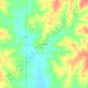
Nom : Carte topographique Moorewood, altitude, relief.
Lieu : Moorewood, Custer County, Oklahoma, United States (35.72033 -99.36899 35.76033 -99.32899)
Altitude moyenne : 557 m
Altitude minimum : 528 m
Altitude maximum : 592 m
Autres cartes topographiques
Cliquez sur une carte pour visualiser sa topographie, son altitude et son relief.
Thomas
United States > Oklahoma > Custer County
Thomas, Custer County, Oklahoma, 73669, United States
Altitude moyenne : 535 m
Arapaho
United States > Oklahoma > Custer County
Arapaho, Custer County, Oklahoma, 73620, United States
Altitude moyenne : 494 m
Clinton
United States > Oklahoma > Custer County
Clinton, Custer County, Oklahoma, 73601, United States
Altitude moyenne : 481 m
Weatherford
United States > Oklahoma > Custer County > Weatherford > Weatherford
Weatherford, Custer County, Oklahoma, 73096, United States
Altitude moyenne : 517 m
Weatherford
United States > Oklahoma > Custer County
Weatherford, Custer County, Oklahoma, 73096, United States
Altitude moyenne : 514 m