
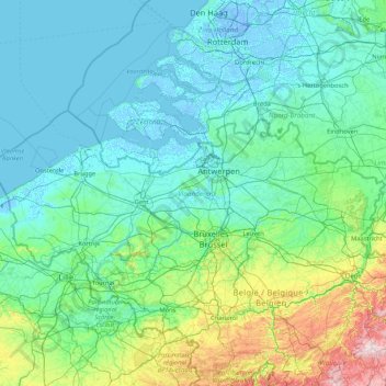
Carte topographique Flanders
Carte interactive
Cliquez sur la carte pour afficher l’altitude.
À propos de cette carte
Nom : Carte topographique Flanders, altitude, relief.
Lieu : Flanders, Belgium (50.68738 2.54136 51.50511 5.91111)
Altitude moyenne : 61 m
Altitude minimum : -7 m
Altitude maximum : 641 m
Autres cartes topographiques
Cliquez sur une carte pour visualiser sa topographie, son altitude et son relief.
La Quéwette
Belgium > Hainaut > Mons > Ghlin
La Quéwette, Ghlin, Mons, Hainaut, Wallonia, 7012, Belgium
Altitude moyenne : 34 m
Kuurne
Belgium > West Flanders > Kortrijk > Kuurne
Kuurne, Kortrijk, West Flanders, Flanders, 8520, Belgium
Altitude moyenne : 17 m
Ghent
Belgium > East Flanders > Gent
Ghent, Gent, East Flanders, Flanders, Belgium
Altitude moyenne : 7 m
Leuven
Belgium > Flemish Brabant > Leuven
Leuven, Flemish Brabant, Flanders, Belgium
Altitude moyenne : 43 m
Michelbeke
Belgium > East Flanders > Oudenaarde > Michelbeke
Michelbeke, Brakel, Oudenaarde, East Flanders, Flanders, Belgium
Altitude moyenne : 59 m
Ronse
Belgium > East Flanders > Oudenaarde > Ronse - Renaix
Ronse, Ronse - Renaix, Ronse, Oudenaarde, East Flanders, Flanders, 9600, Belgium
Altitude moyenne : 61 m
Battle of Waterloo
Belgium > Walloon Brabant > Waterloo
Battle of Waterloo, Route du Lion, Waterloo, Nivelles, Walloon Brabant, Wallonia, 1410, Belgium
Altitude moyenne : 121 m
Hergenrath
Belgium > Liège > Verviers > Kelmis - La Calamine
Hergenrath, Kelmis - La Calamine, Verviers, Liège, Wallonia, 4728, Belgium
Altitude moyenne : 243 m
Hollogne-aux-Pierres
Belgium > Liège > Liège > Grâce-Hollogne
Hollogne-aux-Pierres, Grâce-Hollogne, Liège, Wallonia, 4460, Belgium
Altitude moyenne : 162 m
Sint-Martens-Latem
Belgium > East Flanders > Gent
Sint-Martens-Latem, Gent, East Flanders, Flanders, Belgium
Altitude moyenne : 8 m
Voorde
Belgium > East Flanders > Aalst
Voorde, Ninove, Aalst, East Flanders, Belgium
Altitude moyenne : 32 m
Ourodenberg
Belgium > Flemish Brabant > Leuven > Aarschot
Ourodenberg, Aarschot, Leuven, Flemish Brabant, 3200, Belgium
Altitude moyenne : 16 m
Nessonvaux
Nessonvaux, Trooz, Liège, Wallonia, 4870, Belgium
Altitude moyenne : 197 m
Wervik
Belgium > West Flanders > Ieper
Wervik, Ieper, West Flanders, Flanders, 8940, Belgium
Altitude moyenne : 25 m
Imde
Belgium > Flemish Brabant > Halle-Vilvoorde > Wolvertem
Imde, Wolvertem, Meise, Halle-Vilvoorde, Flemish Brabant, Flanders, 1861, Belgium
Altitude moyenne : 20 m
Rijkevorsel
Rijkevorsel, Turnhout, Antwerp, Flanders, 2310, Belgium
Altitude moyenne : 24 m
Heurne
Belgium > East Flanders > Oudenaarde > Oudenaarde
Heurne, Oudenaarde, East Flanders, Flanders, Belgium
Altitude moyenne : 17 m
Houthulst
Belgium > West Flanders > Diksmuide
Houthulst, Diksmuide, West Flanders, Flanders, 8650, Belgium
Altitude moyenne : 18 m
Torhout
Belgium > West Flanders > Brugge
Torhout, Brugge, West Flanders, Flanders, 8820, Belgium
Altitude moyenne : 22 m
Wemmel
Belgium > Flemish Brabant > Halle-Vilvoorde
Wemmel, Halle-Vilvoorde, Flemish Brabant, 1780, Belgium
Altitude moyenne : 51 m
Boonwijk
Belgium > East Flanders > Dendermonde > Dendermonde > Sint-Gillis-bij-Dendermonde
Boonwijk, Sint-Gillis-bij-Dendermonde, Dendermonde, East Flanders, 9200, Belgium
Altitude moyenne : 4 m
Den Dotter
Belgium > East Flanders > Aalst > Haaltert
Den Dotter, Gotegemstraat, Haaltert, Aalst, East Flanders, 9450, Belgium
Altitude moyenne : 45 m
Schönberg
Belgium > Liège > Verviers > Saint Vith
Schönberg, Saint Vith, Verviers, Liège, Wallonia, 4780, Belgium
Altitude moyenne : 493 m
Conrad
Belgium > Namur > Dinant > Vresse-sur-Semois
Conrad, Vresse-sur-Semois, Dinant, Namur, Wallonia, 5550, Belgium
Altitude moyenne : 314 m
Heuvelland
Belgium > West Flanders > Ieper
Heuvelland, Ieper, West Flanders, Belgium
Altitude moyenne : 35 m
Forchies-la-Marche
Belgium > Hainaut > Charleroi > Fontaine-l'Évêque
Forchies-la-Marche, Fontaine-l'Évêque, Charleroi, Hainaut, Wallonia, 6141, Belgium
Altitude moyenne : 171 m
Sint-Lievens-Esse
Belgium > East Flanders > Aalst
Sint-Lievens-Esse, Herzele, Aalst, East Flanders, Flanders, Belgium
Altitude moyenne : 61 m
Sombeke
Belgium > East Flanders > Dendermonde > Waasmunster
Sombeke, Waasmunster, Dendermonde, East Flanders, Flanders, 9250, Belgium
Altitude moyenne : 15 m
Kaster
Belgium > West Flanders > Kortrijk > Anzegem
Kaster, Anzegem, Kortrijk, West Flanders, 8572, Belgium
Altitude moyenne : 25 m
Meer
Belgium > Antwerp > Turnhout > Hoogstraten
Meer, Hoogstraten, Turnhout, Antwerp, Flanders, 2321, Belgium
Altitude moyenne : 11 m
Anzegem
Belgium > West Flanders > Kortrijk
Anzegem, Kortrijk, West Flanders, Belgium
Altitude moyenne : 32 m
Eeklo
Belgium > East Flanders > Eeklo > Eeklo
Eeklo, East Flanders, Flanders, 9900, Belgium
Altitude moyenne : 5 m
Hollogne-sur-Geer
Hollogne-sur-Geer, Geer, Waremme, Liège, Wallonia, 4250, Belgium
Altitude moyenne : 129 m