
Carte topographique Bongará
Carte interactive
Cliquez sur la carte pour afficher l’altitude.
À propos de cette carte
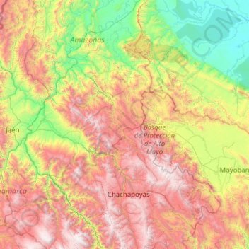
Nom : Carte topographique Bongará, altitude, relief.
Lieu : Bongará, Amazonas, Peru (-6.67457 -78.90194 -4.67457 -76.90194)
Altitude moyenne : 1 439 m
Altitude minimum : 124 m
Altitude maximum : 3 957 m
Autres cartes topographiques
Cliquez sur une carte pour visualiser sa topographie, son altitude et son relief.
San Cristóbal
Peru > Amazonas > San Cristóbal
San Cristóbal, Luya, Amazonas, Peru
Altitude moyenne : 2 283 m
Pedro Ruiz Gallo
Pedro Ruiz Gallo, Jazán, Bongará, Amazonas, 01130, Peru
Altitude moyenne : 1 598 m