
Carte topographique Moab
Carte interactive
Cliquez sur la carte pour afficher l’altitude.
À propos de cette carte
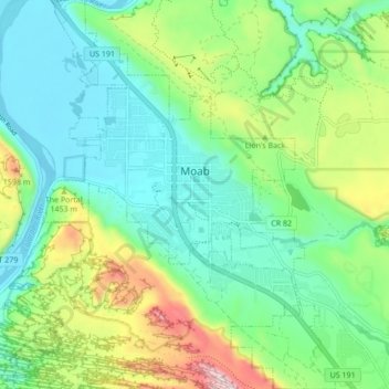
Nom : Carte topographique Moab, altitude, relief.
Lieu : Moab, Grand County, Utah, 84532, United States (38.53621 -109.57965 38.60318 -109.51532)
Altitude moyenne : 1 357 m
Altitude minimum : 1 200 m
Altitude maximum : 1 746 m
Moab is just south of the Colorado River, at an elevation of 4,025 feet (1,227 m) on the Colorado Plateau. It is 18 miles (29 km) west of the Utah/Colorado state line. Via U.S. Route 191, it is 31 miles (50 km) south of Interstate 70 at Crescent Junction, and it is 54 miles (87 km) north of Monticello. Via Utah State Route 128 it is 46 miles (74 km) southwest of Cisco. The entrance to Arches National Park is 4 miles (6 km) north of Moab on US 191. Hurrah Pass is located on the trail between Moab and Chicken Corners.
Autres cartes topographiques
Cliquez sur une carte pour visualiser sa topographie, son altitude et son relief.
Manns Peak
United States > Utah > Grand County
Manns Peak, Grand County, Utah, United States
Altitude moyenne : 3 427 m
Castle Valley
United States > Utah > Grand County
Castle Valley, Grand County, Utah, United States
Altitude moyenne : 1 610 m
Castleton Tower
United States > Utah > Grand County
Castleton Tower, Grand County, Utah, United States
Altitude moyenne : 1 549 m
Arches National Park
United States > Utah > Grand County
Arches National Park, Grand County, Utah, United States
Altitude moyenne : 1 476 m