
Carte topographique Maluti-a-Phofung Ward 27
Carte interactive
Cliquez sur la carte pour afficher l’altitude.
À propos de cette carte
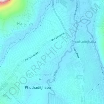
Nom : Carte topographique Maluti-a-Phofung Ward 27, altitude, relief.
Altitude moyenne : 1 670 m
Altitude minimum : 1 634 m
Altitude maximum : 2 105 m
Autres cartes topographiques
Cliquez sur une carte pour visualiser sa topographie, son altitude et son relief.
Sterkfontein Dam Nature Reserve
RSA > Free State > Maluti-a-Phofung Local Municipality
Sterkfontein Dam Nature Reserve, Blesbuck, Maluti-a-Phofung Ward 6, Maluti-a-Phofung Local Municipality, Thabo Mofutsanyana District Municipality, Free State, RSA
Altitude moyenne : 1 766 m
Maluti-a-Phofung Ward 20
RSA > Free State > Maluti-a-Phofung Local Municipality
Maluti-a-Phofung Ward 20, Maluti-a-Phofung Local Municipality, Thabo Mofutsanyana District Municipality, Free State, RSA
Altitude moyenne : 2 228 m