
Faire un don
Équipez-vous pour votre prochaine aventure :
En tant que Partenaire Amazon, ce site perçoit une commission sur les achats éligibles sans surcoût pour vous.
Carte topographique Navsari
Cliquez sur la carte pour afficher l’altitude.
Faire un don
Équipez-vous pour votre prochaine aventure :
En tant que Partenaire Amazon, ce site perçoit une commission sur les achats éligibles sans surcoût pour vous.
Navsari
Navsari is located at 20°57′N 72°56′E / 20.95°N 72.93°E / 20.95; 72.93. It has an average elevation of 9 metres or 30 feet above sea level. The city is located in southern Gujarat and is situated near the Purna River, within a few kilometres of the river's delta, which is west of the city and empties into the Gulf of Khambhat. The weather in Navsari is sunny from October to May, and rainy from June to September. The average maximum and minimum temperatures are 42 °C (107.6 °F) and 17 °C (62.6 °F) respectively. The average annual rainfall is 122 cm (48 in).
Faire un don
Équipez-vous pour votre prochaine aventure :
En tant que Partenaire Amazon, ce site perçoit une commission sur les achats éligibles sans surcoût pour vous.
À propos de cette carte
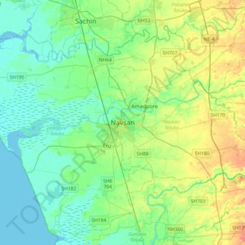
Nom : Carte topographique Navsari, altitude, relief.
Lieu : Navsari, Navsari Taluka, Navsari, Gujarat, 396400, India (20.79241 72.77238 21.11241 73.09238)
Altitude moyenne : 14 m
Altitude minimum : -2 m
Altitude maximum : 45 m
Faire un don
Équipez-vous pour votre prochaine aventure :
En tant que Partenaire Amazon, ce site perçoit une commission sur les achats éligibles sans surcoût pour vous.