
Carte topographique Habersham County
Carte interactive
Cliquez sur la carte pour afficher l’altitude.
À propos de cette carte
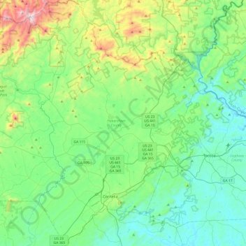
Nom : Carte topographique Habersham County, altitude, relief.
Lieu : Habersham County, Georgia, United States (34.43119 -83.68168 34.82781 -83.33816)
Altitude moyenne : 448 m
Altitude minimum : 198 m
Altitude maximum : 1 312 m
The highest point in the county is a 4,400-foot (1,300 m) knob less than 700 feet (210 m) southeast of the top of Tray Mountain, the seventh-highest mountain in Georgia. Habersham shares this portion of Tray Mountain, just 30 vertical feet shy of the peak's 4,430-foot summit, with White County to the west and Towns County to the north. 2.4 miles to the northeast of Tray Mountain is Young Lick (elevation 3,809 feet (1,161 m)). The Appalachian Trail runs along the top of the high ridge between Young Lick and Tray, a part of the Blue Ridge Mountain crest.
Autres cartes topographiques
Cliquez sur une carte pour visualiser sa topographie, son altitude et son relief.
Cherokee County
Cherokee County, Georgia, United States
Altitude moyenne : 332 m
Marietta
United States > Georgia > Cobb County
Marietta, Cobb County, Georgia, United States
Altitude moyenne : 323 m
Canton
United States > Georgia > Cherokee County
Canton, Cherokee County, Georgia, United States
Altitude moyenne : 320 m
Woodstock
United States > Georgia > Cherokee County
Woodstock, Cherokee County, Georgia, United States
Altitude moyenne : 296 m
Kennesaw
United States > Georgia > Cobb County
Kennesaw, Cobb County, Georgia, United States
Altitude moyenne : 317 m
Holly Springs
United States > Georgia > Cherokee County
Holly Springs, Cherokee County, Georgia, United States
Altitude moyenne : 306 m
Statham
United States > Georgia > Barrow County > Statham
Statham, Barrow County, Georgia, 30666, United States
Altitude moyenne : 261 m
Worley Crossroads
United States > Georgia > Cherokee County > Worley Crossroads
Worley Crossroads, Cherokee County, Georgia, United States
Altitude moyenne : 378 m
Watkinsville
United States > Georgia > Watkinsville
Watkinsville, Oconee County, Georgia, 30644, United States
Altitude moyenne : 218 m