
Carte topographique Biljurashi
Carte interactive
Cliquez sur la carte pour afficher l’altitude.
Biljurashi
Baljurashi (Arabic: بَـلْـجُـرَشِي) or Biljurashi (Arabic: بِـلْـجُـرَشِي) is a city in Al Bahah Region, south-western Saudi Arabia. It is located at around 19°51′40″N 41°33′40″E / 19.8612090°N 41.5609769°E / 19.8612090; 41.5609769 in the elevation of cca 2,000 metres (6,600 feet). It was the capital of the region which includes the tribes of Ghamid and Zahran. It is a medium-sized city in Al Bahah Region. The temperature usually varies between 2 °C (36 °F) in winter and 30 °C (86 °F) in summer. The best time for a visit is from mid-August till the end of September. Most of the native people of Baljurashi live outside it; however, a great number of them spend their summer vacations in the city, which explains the massive increase in population number during summer.
À propos de cette carte
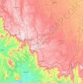
Nom : Carte topographique Biljurashi, altitude, relief.
Lieu : Biljurashi, Al-Bahah Province, Saudi Arabia (19.69809 41.50283 20.29958 41.97897)
Altitude moyenne : 1 528 m
Altitude minimum : 268 m
Altitude maximum : 2 563 m
Autres cartes topographiques
Cliquez sur une carte pour visualiser sa topographie, son altitude et son relief.
Al Bahah
Saudi Arabia > Al-Bahah Province
Al-Baha is the homeland of the Ghamid and Zahran tribes and is divided geographically into three distinct parts: Sarah, which contains the high Hijaz mountains characterized by temperate weather and rich plant cover due to relatively high annual rainfall, the Tihamah which is the lowland coastal area to the…
Altitude moyenne : 1 744 m