
Carte topographique Kangan
Carte interactive
Cliquez sur la carte pour afficher l’altitude.
À propos de cette carte
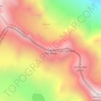
Nom : Carte topographique Kangan, altitude, relief.
Altitude moyenne : 4 199 m
Altitude minimum : 3 266 m
Altitude maximum : 4 829 m
Autres cartes topographiques
Cliquez sur une carte pour visualiser sa topographie, son altitude et son relief.
Shane
India > Jammu and Kashmir > Kishtwar
Shane, Kishtwar, Kishtwar District, Jammu and Kashmir, India
Altitude moyenne : 1 769 m
Kishtwar
Kishtwar, Kishtwar district, Jammu and Kashmir, India
Altitude moyenne : 2 605 m
Bhaderwah
India > Jammu and Kashmir > Bhaderwah
Bhaderwah, Doda District, Jammu and Kashmir, 182222, India
Altitude moyenne : 2 511 m
Rajouri
India > Jammu and Kashmir > Rajauri > Rajouri
Rajouri, Rajauri, Rajouri district, Jammu and Kashmir, 185131, India
Altitude moyenne : 1 038 m
Beerwah
India > Jammu and Kashmir > Beerwah
Beerwah, Budgam District, Jammu and Kashmir, India
Altitude moyenne : 1 785 m
Beerwah
India > Jammu and Kashmir > Beerwah tehsil
Beerwah, Beerwah tehsil, Budgam District, Jammu and Kashmir, 193411, India
Altitude moyenne : 1 803 m
Sonamarg
India > Jammu and Kashmir > Sonamarg
Sonamarg, Ganderbal, Jammu and Kashmir, India
Altitude moyenne : 3 354 m
Tso Moriri
Tso Moriri, Leh District, Jammu and Kashmir, India
Altitude moyenne : 5 044 m
Siachen Glacier
Siachen Glacier, Leh District, Ladakh, India
Altitude moyenne : 5 448 m
Central Chong Kumdan Glacier
Central Chong Kumdan Glacier, Leh District, Jammu and Kashmir, India
Altitude moyenne : 5 823 m
South Rimo Glacier
South Rimo Glacier, Leh District, Jammu and Kashmir, India
Altitude moyenne : 5 595 m
Nubra
India > Jammu and Kashmir > Leh
Nubra, Leh, Leh District, Jammu and Kashmir, India
Altitude moyenne : 3 205 m