
Carte topographique Narra
Carte interactive
Cliquez sur la carte pour afficher l’altitude.
À propos de cette carte
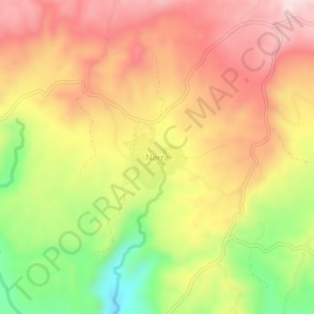
Nom : Carte topographique Narra, altitude, relief.
Lieu : Narra, Bayawan, Negros Oriental, Central Visayas, Philippines (9.43126 122.86412 9.47126 122.90412)
Altitude moyenne : 274 m
Altitude minimum : 57 m
Altitude maximum : 438 m
Autres cartes topographiques
Cliquez sur une carte pour visualiser sa topographie, son altitude et son relief.
Nangka
Philippines > Negros Oriental > Bayawan
Nangka, Bayawan, Negros Oriental, Central Visayas, 6221, Philippines
Altitude moyenne : 25 m
Banga
Philippines > Negros Oriental > Bayawan > Cabcabon Hills
Banga, Cabcabon Hills, Bayawan, Negros Oriental, Central Visayas, 6221, Philippines
Altitude moyenne : 48 m