
Carte topographique Cape Clear
Carte interactive
Cliquez sur la carte pour afficher l’altitude.
À propos de cette carte
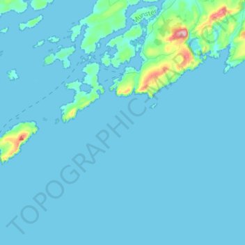
Nom : Carte topographique Cape Clear, altitude, relief.
Lieu : Cape Clear, West Cork, County Cork, Munster, P81 FY05, Ireland (51.38887 -9.60321 51.51625 -9.35321)
Altitude moyenne : 10 m
Altitude minimum : -2 m
Altitude maximum : 190 m
Autres cartes topographiques
Cliquez sur une carte pour visualiser sa topographie, son altitude et son relief.
Millstreet
Millstreet, Municipal District of Macroom, County Cork, Munster, Ireland
Altitude moyenne : 140 m
Whitechurch
Whitechurch, Municipal District of Cobh, County Cork, Munster, Ireland
Altitude moyenne : 110 m
Waterfall
Waterfall, Inishkenny, Municipal District of Carrigaline, County Cork, Munster, T12 CYF2, Ireland
Altitude moyenne : 96 m
Cloyne
Cloyne, Cloyne ED, The Municipal District of East Cork, County Cork, Munster, P25 P792, Ireland
Altitude moyenne : 40 m
Killeagh
Killeagh, The Municipal District of East Cork, County Cork, Munster, P36 KN61, Ireland
Altitude moyenne : 64 m
Kilquane
Ireland > County Cork > Municipal District of Cobh
Kilquane, Knockraha, Municipal District of Cobh, County Cork, Munster, Ireland
Altitude moyenne : 131 m
Knockraha
Ireland > County Cork > Municipal District of Cobh
Knockraha, Municipal District of Cobh, County Cork, Munster, T45 P840, Ireland
Altitude moyenne : 140 m
Cloyne
Ireland > County Cork > Cloyne
Cloyne, The Municipal District of East Cork, County Cork, Munster, P25 P792, Ireland
Altitude moyenne : 43 m