
Carte topographique Lake Saint Clair
Carte interactive
Cliquez sur la carte pour afficher l’altitude.
À propos de cette carte
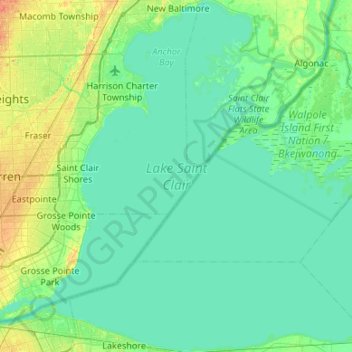
Nom : Carte topographique Lake Saint Clair, altitude, relief.
Altitude moyenne : 177 m
Altitude minimum : 171 m
Altitude maximum : 199 m
Autres cartes topographiques
Cliquez sur une carte pour visualiser sa topographie, son altitude et son relief.
Van Buren County
United States of America > Michigan
Hamilton Township, Van Buren County, Michigan, United States of America
Altitude moyenne : 237 m
Genesee County
United States of America > Michigan
Genesee County, Michigan, United States of America
Altitude moyenne : 246 m
Mackinac County
United States of America > Michigan
Mackinac County, Michigan, United States of America
Altitude moyenne : 206 m
Isabella County
United States of America > Michigan
Isabella County, Michigan, United States of America
Altitude moyenne : 261 m
Ann Arbor
United States of America > Michigan > Ann Arbor
Ann Arbor, Washtenaw County, Michigan, United States of America
Altitude moyenne : 268 m
Portage
United States of America > Michigan > Portage
Portage, Kalamazoo County, Michigan, United States of America
Altitude moyenne : 266 m
Baraga County
United States of America > Michigan
Baraga County, Michigan, United States of America
Altitude moyenne : 378 m
Ontonagon County
United States of America > Michigan
Ontonagon County, Michigan, United States of America
Altitude moyenne : 334 m
Washtenaw County
United States of America > Michigan
Washtenaw County, Michigan, United States of America
Altitude moyenne : 267 m
Sanilac County
United States of America > Michigan
Sanilac County, Michigan, United States of America
Altitude moyenne : 228 m