
Carte topographique Bingerville
Carte interactive
Cliquez sur la carte pour afficher l’altitude.
À propos de cette carte
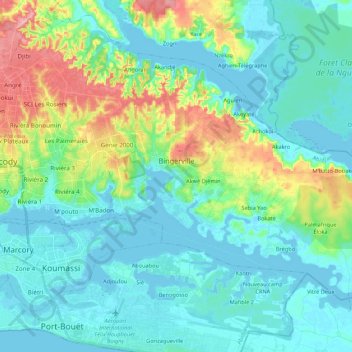
Nom : Carte topographique Bingerville, altitude, relief.
Lieu : Bingerville, Abidjan, Côte d’Ivoire (5.27283 -3.93325 5.42398 -3.71774)
Altitude moyenne : 27 m
Altitude minimum : -5 m
Altitude maximum : 120 m
Autres cartes topographiques
Cliquez sur une carte pour visualiser sa topographie, son altitude et son relief.
Djorogobité
Côte d’Ivoire > Abidjan > Cocody
Djorogobité, Cocody, Abidjan, Côte d’Ivoire
Altitude moyenne : 57 m
Locodjro
Côte d’Ivoire > Abidjan > Attécoubé
Locodjro, Attécoubé, Abidjan, Côte d’Ivoire
Altitude moyenne : 20 m
Songon-Kassemblé
Côte d’Ivoire > Abidjan > Songon-Kassemblé
Songon-Kassemblé, Songon, Abidjan, Côte d’Ivoire
Altitude moyenne : 17 m
Ahoué
Côte d’Ivoire > Abidjan > Anyama > Ahoué
Ahoué, Anyama, Abidjan, Côte d’Ivoire
Altitude moyenne : 42 m
Attinguié
Côte d’Ivoire > Abidjan > Anyama > Attinguié
Attinguié, Anyama, Abidjan, Côte d’Ivoire
Altitude moyenne : 31 m
Genie 2000
Côte d’Ivoire > Abidjan > Cocody
Genie 2000, Cocody, Abidjan, Côte d’Ivoire
Altitude moyenne : 61 m
Songon-Agban Attié II
Côte d’Ivoire > Abidjan > Songon-Agban Attié II
Songon-Agban Attié II, Songon, Abidjan, Côte d’Ivoire
Altitude moyenne : 48 m