
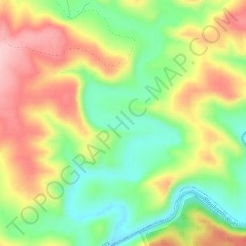
Carte topographique Kowie River
Carte interactive
Cliquez sur la carte pour afficher l’altitude.
À propos de cette carte
Nom : Carte topographique Kowie River, altitude, relief.
Altitude moyenne : 240 m
Altitude minimum : 144 m
Altitude maximum : 351 m
Autres cartes topographiques
Cliquez sur une carte pour visualiser sa topographie, son altitude et son relief.
Thomas Baines Nature Reserve
RSA > Eastern Cape > Makana Local Municipality
Thomas Baines Nature Reserve, R343, Makana Ward 13, Makana Local Municipality, Sarah Baartman District Municipality, Eastern Cape, RSA
Altitude moyenne : 373 m
Shamwari Private Game Reserve
RSA > Eastern Cape > Makana Local Municipality
Shamwari Private Game Reserve, Makana Ward 14, Makana Local Municipality, Sarah Baartman District Municipality, Eastern Cape, RSA
Altitude moyenne : 356 m
Coleridge Game Reserve
RSA > Eastern Cape > Makana Local Municipality
Coleridge Game Reserve, R67, Makana Ward 13, Makana Local Municipality, Sarah Baartman District Municipality, Eastern Cape, 6139, RSA
Altitude moyenne : 392 m
Makana Ward 6
RSA > Eastern Cape > Makana Local Municipality
Makana Ward 6, Makana Local Municipality, Sarah Baartman District Municipality, Eastern Cape, RSA
Altitude moyenne : 637 m