
Carte topographique Xiashan District
Carte interactive
Cliquez sur la carte pour afficher l’altitude.
À propos de cette carte
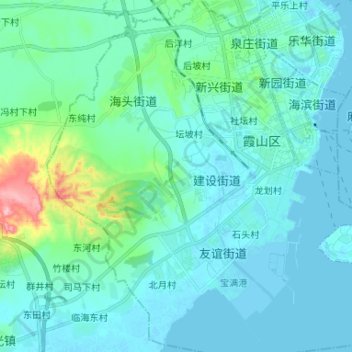
Nom : Carte topographique Xiashan District, altitude, relief.
Lieu : Xiashan District, Zhanjiang City, Guangdong, PRC (21.12049 110.31531 21.24295 110.44235)
Altitude moyenne : 22 m
Altitude minimum : -4 m
Altitude maximum : 157 m
Autres cartes topographiques
Cliquez sur une carte pour visualiser sa topographie, son altitude et son relief.
Guangzhou City
PRC > Guangdong > Guangzhou City
Baiyun, Baiyun District, Guangzhou City, Guangdong, 510091, PRC
Altitude moyenne : 24 m
Yunfu City
PRC > Guangdong > Yunfu City
Xincheng, Xinxing County, Yunfu City, Guangdong, PRC
Altitude moyenne : 101 m
Guishan Island
PRC > Guangdong > Kuishan island
Guishan Island, Kuishan island, Xiangzhou District, Zhuhai City, Guangdong, PRC
Altitude moyenne : 25 m
Shekou
PRC > Guangdong > Shenzhen City > Shekou
Shekou, Nanshan district, Shenzhen City, Guangdong, 518000, PRC
Altitude moyenne : 11 m
Sha Lo Wan
PRC > Guangdong > Shenzhen City > Sha Lo Wan Chung Hau
Sha Lo Wan, Hong Kong-Zhuhai-Macao Bridge Hong Kong Link Road, Sha Lo Wan, Sha Lo Wan Chung Hau, Islands District, Shenzhen City, Guangdong, Hong Kong, PRC
Altitude moyenne : 43 m