Carte topographique Secunderabad
Carte interactive
Cliquez sur la carte pour afficher l’altitude.
Secunderabad
Situated in the North of Hyderabad at 17°27′N 78°30′E / 17.45°N 78.5°E / 17.45; 78.5., Secunderabad lies on the northern part of the Deccan Plateau. Secunderabad has an average elevation of 543 metres (1781 ft). Most of the area has a rocky terrain and some areas are hilly.
À propos de cette carte

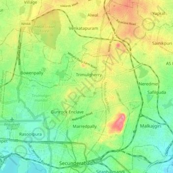
Nom : Carte topographique Secunderabad, altitude, relief.
Lieu : Secunderabad, Hyderabad, Telangana, 500003, India (17.27372 78.34068 17.59372 78.66068)
Altitude moyenne : 544 m
Altitude minimum : 446 m
Altitude maximum : 634 m
Autres cartes topographiques
Cliquez sur une carte pour visualiser sa topographie, son altitude et son relief.

Hyderabad
India > Telangana > Bahadurpura mandal
Hyderabad (/ˈhaɪdərəbæd/ HY-dər-ə-bad; Telugu: [ˈɦaɪ̯daraːbaːd], Urdu: [ˈɦɛːdəɾaːbaːd]) is the capital and largest city of the Indian state of Telangana. It occupies 650 km2 (250 sq mi) on the Deccan Plateau along the banks of the Musi River, in the northern part of Southern India. With an…
Altitude moyenne : 549 m

Link-I (Kaleshwaram Lift Irrigation Project, North Part)
India > Telangana > Anthergaon mandal > Goilwada
Altitude moyenne : 144 m

Hyderabad
India > Telangana > Bahadurpura mandal
Hyderabad (Telugu: Haidarābād , pronounced [ˈɦaɪ̯dəɾaːbaːd]; Urdu: [ˈɦɛːdəɾaːbaːd]) is the capital and largest city of the Indian state of Telangana. It occupies 650 km2 (250 sq mi) on the Deccan Plateau along the banks of the Musi River, in the northern part of Southern India. With an…
Altitude moyenne : 549 m

Nallamala Hills
The Nallamalas (also called the Nallamalla Range) are a section of the Eastern Ghats which forms the eastern boundary of Rayalaseema region of the state of Andhra Pradesh and Mahabubnagar, Nalgonda districts of the state of Telangana, in India. They run in a nearly north-south alignment, parallel to the…
Altitude moyenne : 278 m

Sri Komaravelli Mallanna Sagar
India > Telangana > Thoguta mandal > Thukkapur
Altitude moyenne : 542 m