
Faire un don
Équipez-vous pour votre prochaine aventure :
En tant que Partenaire Amazon, ce site perçoit une commission sur les achats éligibles sans surcoût pour vous.
Carte topographique Drayton Valley (town)
Cliquez sur la carte pour afficher l’altitude.
Faire un don
Équipez-vous pour votre prochaine aventure :
En tant que Partenaire Amazon, ce site perçoit une commission sur les achats éligibles sans surcoût pour vous.
À propos de cette carte
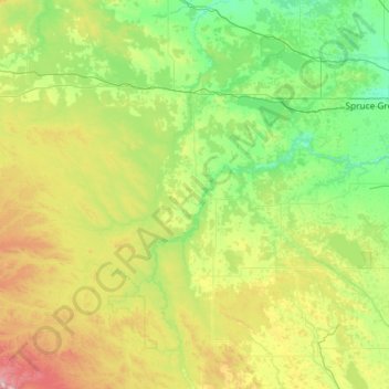
Nom : Carte topographique Drayton Valley (town), altitude, relief.
Lieu : Drayton Valley (town), Alberta, T7A 1J5, Canada (52.51749 -115.67901 53.91749 -114.27901)
Altitude moyenne : 892 m
Altitude minimum : 638 m
Altitude maximum : 2 031 m
Faire un don
Équipez-vous pour votre prochaine aventure :
En tant que Partenaire Amazon, ce site perçoit une commission sur les achats éligibles sans surcoût pour vous.
Autres cartes topographiques
Cliquez sur une carte pour visualiser sa topographie, son altitude et son relief.
Faire un don
Équipez-vous pour votre prochaine aventure :
En tant que Partenaire Amazon, ce site perçoit une commission sur les achats éligibles sans surcoût pour vous.
Medicine Lake
Canada > Alberta > Improvement District No. 12
Wildlife is surprisingly abundant along this high altitude lake. Grizzly bear, black bear, mule deer, caribou, wolves, moose and mountain sheep are some of the larger mammals that frequent the lake area during the summer season. Bald eagles, and osprey also frequent the area and live off the fish populations.
Altitude moyenne : 1 681 m
Faire un don
Équipez-vous pour votre prochaine aventure :
En tant que Partenaire Amazon, ce site perçoit une commission sur les achats éligibles sans surcoût pour vous.
Faire un don
Équipez-vous pour votre prochaine aventure :
En tant que Partenaire Amazon, ce site perçoit une commission sur les achats éligibles sans surcoût pour vous.
Bow Lake
Canada > Alberta > Division No. 15
Bow Lake is a small lake in western Alberta, Canada. It is located on the Bow River, in the Canadian Rockies, at an altitude of 1920 m.
Altitude moyenne : 2 165 m
Faire un don
Équipez-vous pour votre prochaine aventure :
En tant que Partenaire Amazon, ce site perçoit une commission sur les achats éligibles sans surcoût pour vous.
William A. Switzer Provincial Park
Canada > Alberta > Yellowhead County
This park is situated within the foothills of Alberta's Rocky Mountains, at an elevation of 1,150 m (3,770 ft) to 1,300 m (4,300 ft) and has a surface of 93 km2 (36 sq mi). It was established on December 22, 1958 and is maintained by Alberta Tourism, Parks and Recreation. The park is named after former…
Altitude moyenne : 1 348 m
Faire un don
Équipez-vous pour votre prochaine aventure :
En tant que Partenaire Amazon, ce site perçoit une commission sur les achats éligibles sans surcoût pour vous.
Faire un don
Équipez-vous pour votre prochaine aventure :
En tant que Partenaire Amazon, ce site perçoit une commission sur les achats éligibles sans surcoût pour vous.
Faire un don
Équipez-vous pour votre prochaine aventure :
En tant que Partenaire Amazon, ce site perçoit une commission sur les achats éligibles sans surcoût pour vous.
Faire un don
Équipez-vous pour votre prochaine aventure :
En tant que Partenaire Amazon, ce site perçoit une commission sur les achats éligibles sans surcoût pour vous.
Faire un don
Équipez-vous pour votre prochaine aventure :
En tant que Partenaire Amazon, ce site perçoit une commission sur les achats éligibles sans surcoût pour vous.
Faire un don
Équipez-vous pour votre prochaine aventure :
En tant que Partenaire Amazon, ce site perçoit une commission sur les achats éligibles sans surcoût pour vous.
Lac Ste. Anne
Canada > Alberta > Lac Ste. Anne County > Village of Alberta Beach
The lake has a total area of 54.5 km2, a maximum depth of 9 m, and an average depth of 4.8 m. Lac Ste. Anne lies at an elevation of 730 m, and has a drainage area of 619 km2. The eutrophic lake is formed along the Sturgeon River through which it drains into the North Saskatchewan River. Two islands are found…
Altitude moyenne : 740 m
Waterton Lakes National Park
Canada > Alberta > Improvement District No. 04
Operated by Parks Canada, Waterton is open all year, but the main tourist season is during July and August. The only commercial facilities available within the park are located at the Waterton Park townsite. This park ranges in elevation from 1,290 metres (4,232 ft) at the townsite to 2,910 m (9,547 ft) at…
Altitude moyenne : 1 778 m
Faire un don
Équipez-vous pour votre prochaine aventure :
En tant que Partenaire Amazon, ce site perçoit une commission sur les achats éligibles sans surcoût pour vous.
Faire un don
Équipez-vous pour votre prochaine aventure :
En tant que Partenaire Amazon, ce site perçoit une commission sur les achats éligibles sans surcoût pour vous.
Faire un don
Équipez-vous pour votre prochaine aventure :
En tant que Partenaire Amazon, ce site perçoit une commission sur les achats éligibles sans surcoût pour vous.
Town of Cochrane
Cochrane is situated at the base of Big Hill in the Bow River Valley. It sits at an elevation of 1,186 m (3,891 ft). The town is intersected by Highway 1A and Highway 22. Cochrane has a reputation for its western culture, which can easily be felt when one wanders the streets (particularly Main Street). The…
Altitude moyenne : 1 200 m
Strathcona Science Provincial Park
Canada > Alberta > Strathcona County > Sherwood Park
The park is situated in the North Saskatchewan River valley, on both banks of the river, at an elevation of 625 m (2,051 ft) and has a surface of 2.9 km2 (1.1 sq mi). It was established on December 12, 1979 and is maintained by Alberta Tourism, Parks and Recreation.
Altitude moyenne : 653 m
Faire un don
Équipez-vous pour votre prochaine aventure :
En tant que Partenaire Amazon, ce site perçoit une commission sur les achats éligibles sans surcoût pour vous.
Faire un don
Équipez-vous pour votre prochaine aventure :
En tant que Partenaire Amazon, ce site perçoit une commission sur les achats éligibles sans surcoût pour vous.
Maligne Lake
Canada > Alberta > Improvement District No. 12
Wildlife is surprisingly abundant along this high altitude oligotrophic lake. Grizzly bear, black bear, mule deer, caribou, wolves, moose, and mountain sheep are some of the larger mammals that frequent the lake area during the summer season. Bald eagles, golden eagles and osprey also frequent the area and…
Altitude moyenne : 2 125 m
Faire un don
Équipez-vous pour votre prochaine aventure :
En tant que Partenaire Amazon, ce site perçoit une commission sur les achats éligibles sans surcoût pour vous.
Faire un don
Équipez-vous pour votre prochaine aventure :
En tant que Partenaire Amazon, ce site perçoit une commission sur les achats éligibles sans surcoût pour vous.
West Bragg Creek Provincial Recreation Area
Canada > Alberta > Kananaskis Improvement District
Altitude moyenne : 1 466 m
Faire un don
Équipez-vous pour votre prochaine aventure :
En tant que Partenaire Amazon, ce site perçoit une commission sur les achats éligibles sans surcoût pour vous.
Faire un don
Équipez-vous pour votre prochaine aventure :
En tant que Partenaire Amazon, ce site perçoit une commission sur les achats éligibles sans surcoût pour vous.
Faire un don
Équipez-vous pour votre prochaine aventure :
En tant que Partenaire Amazon, ce site perçoit une commission sur les achats éligibles sans surcoût pour vous.
Faire un don
Équipez-vous pour votre prochaine aventure :
En tant que Partenaire Amazon, ce site perçoit une commission sur les achats éligibles sans surcoût pour vous.
Town of Slave Lake
Canada > Alberta > Municipal District of Lesser Slave River
Altitude moyenne : 589 m
Faire un don
Équipez-vous pour votre prochaine aventure :
En tant que Partenaire Amazon, ce site perçoit une commission sur les achats éligibles sans surcoût pour vous.
Redcliff
Situated at a high elevation relative to the surrounding landscape, the Town of Redcliff offers views of the South Saskatchewan River valley, the City of Medicine Hat, and Cypress Hills. The cliffs that overlook the river valley resemble badland formations.
Altitude moyenne : 727 m
Faire un don
Équipez-vous pour votre prochaine aventure :
En tant que Partenaire Amazon, ce site perçoit une commission sur les achats éligibles sans surcoût pour vous.