
Faire un don
Équipez-vous pour votre prochaine aventure :
En tant que Partenaire Amazon, ce site perçoit une commission sur les achats éligibles sans surcoût pour vous.
Carte topographique Stavanger
Cliquez sur la carte pour afficher l’altitude.
Faire un don
Équipez-vous pour votre prochaine aventure :
En tant que Partenaire Amazon, ce site perçoit une commission sur les achats éligibles sans surcoût pour vous.
Stavanger
The municipality of Stavanger is located in a coastal landscape, bordering the sea to the west and Boknafjorden in the northeast. The Byfjorden and Gandsfjorden run along the east side of the city. It is part of the Low-Jæren, a flat area of land consisting mostly of marsh, sand, and stone aur, that ranges from Ogna River in the south to Tungenes in the north; it is the northernmost part that includes Stavanger. The majority of the municipality lies between 0 and 50 m (0 and 164 ft) in elevation. The landscape has a distinctive appearance with rocks and hills where there is no settlement or agriculture. The city of Stavanger is closely linked to the sea and water, with five lakes (including Breiavatnet, Stora Stokkavatnet, and Mosvatnet) and three fjords (Hafrsfjorden, Byfjorden, and Gandsfjorden); sea and water form the landscape, providing a shoreline rich with vegetation and wildlife.
Faire un don
Équipez-vous pour votre prochaine aventure :
En tant que Partenaire Amazon, ce site perçoit une commission sur les achats éligibles sans surcoût pour vous.
À propos de cette carte
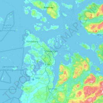
Nom : Carte topographique Stavanger, altitude, relief.
Lieu : Stavanger, Rogaland, 4006, Norway (58.80997 5.57181 59.12997 5.89181)
Altitude moyenne : 44 m
Altitude minimum : -1 m
Altitude maximum : 552 m
Faire un don
Équipez-vous pour votre prochaine aventure :
En tant que Partenaire Amazon, ce site perçoit une commission sur les achats éligibles sans surcoût pour vous.
Autres cartes topographiques
Cliquez sur une carte pour visualiser sa topographie, son altitude et son relief.
Faire un don
Équipez-vous pour votre prochaine aventure :
En tant que Partenaire Amazon, ce site perçoit une commission sur les achats éligibles sans surcoût pour vous.
Faire un don
Équipez-vous pour votre prochaine aventure :
En tant que Partenaire Amazon, ce site perçoit une commission sur les achats éligibles sans surcoût pour vous.
Faire un don
Équipez-vous pour votre prochaine aventure :
En tant que Partenaire Amazon, ce site perçoit une commission sur les achats éligibles sans surcoût pour vous.
Faire un don
Équipez-vous pour votre prochaine aventure :
En tant que Partenaire Amazon, ce site perçoit une commission sur les achats éligibles sans surcoût pour vous.
Faire un don
Équipez-vous pour votre prochaine aventure :
En tant que Partenaire Amazon, ce site perçoit une commission sur les achats éligibles sans surcoût pour vous.
Stavanger
The municipality of Stavanger is located in a coastal landscape, bordering the sea to the west and Boknafjorden in the northeast. The Byfjorden and Gandsfjorden run along the east side of the city. It is part of the Low-Jæren, a flat area of land consisting mostly of marsh, sand, and stone aur, that ranges…
Altitude moyenne : 42 m
Faire un don
Équipez-vous pour votre prochaine aventure :
En tant que Partenaire Amazon, ce site perçoit une commission sur les achats éligibles sans surcoût pour vous.
Faire un don
Équipez-vous pour votre prochaine aventure :
En tant que Partenaire Amazon, ce site perçoit une commission sur les achats éligibles sans surcoût pour vous.
Stavanger
The municipality of Stavanger is located in a coastal landscape, bordering the sea to the west and Boknafjorden in the northeast. The Byfjorden and Gandsfjorden run along the east side of the city. It is part of the Low-Jæren, a flat area of land consisting mostly of marsh, sand, and stone aur, that ranges…
Altitude moyenne : 37 m
Faire un don
Équipez-vous pour votre prochaine aventure :
En tant que Partenaire Amazon, ce site perçoit une commission sur les achats éligibles sans surcoût pour vous.
Stavanger
The municipality of Stavanger is located in a coastal landscape, bordering the sea to the west and Boknafjorden in the northeast. The Byfjorden and Gandsfjorden run along the east side of the city. It is part of the Low-Jæren, a flat area of land consisting mostly of marsh, sand, and stone aur, that ranges…
Altitude moyenne : 42 m
Faire un don
Équipez-vous pour votre prochaine aventure :
En tant que Partenaire Amazon, ce site perçoit une commission sur les achats éligibles sans surcoût pour vous.