
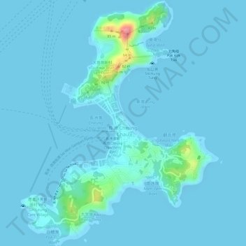
Carte topographique Cheung Chau
Carte interactive
Cliquez sur la carte pour afficher l’altitude.
À propos de cette carte
Nom : Carte topographique Cheung Chau, altitude, relief.
Altitude moyenne : 6 m
Altitude minimum : -2 m
Altitude maximum : 93 m
Autres cartes topographiques
Cliquez sur une carte pour visualiser sa topographie, son altitude et son relief.
Hong Kong Island
Hong Kong Island, Southern District, Hong Kong Island, Hong Kong, China
Altitude moyenne : 53 m
Lion Rock Country Park
China > Hong Kong > Hung Mui Kuk > Kak Tin
Lion Rock Country Park, Chui Tin Street, Sha Tin Area 5A, Kak Tin, New Territories, Hung Mui Kuk, Sha Tin District, Hong Kong, China
Altitude moyenne : 134 m
Tuen Mun District
Tuen Mun District, New Territories, Hong Kong, China
Altitude moyenne : 37 m
Yau Tsim Mong District
Yau Tsim Mong District, Kowloon, Hong Kong, 00000, China
Altitude moyenne : 11 m
Eastern District
Eastern District, Hong Kong Island, Hong Kong, China
Altitude moyenne : 84 m
Kowloon City District
Kowloon City District, Kowloon, Hong Kong, China
Altitude moyenne : 36 m
Mui Tsz Lam
China > Hong Kong > Mui Tsz Lam
Lai Chi Wo, Mui Tsz Lam, North District, New Territories, Hong Kong, China
Altitude moyenne : 76 m
Tai Po Kau Lo Wai
China > Hong Kong > Tai Po Kau Lo Wai
Tai Po Kau Lo Wai, Tai Po District, New Territories, Hong Kong, DD29 1007, China
Altitude moyenne : 80 m
Coral Beach
China > Hong Kong > Seanic Garden
Coral Beach, Cheung Chau Family Walk, Chi Ma Wan Peninsula, Seanic Garden, Islands District, New Territories, Hong Kong, CCL 1625, China
Altitude moyenne : 4 m
Lion Rock Upper Village
China > Hong Kong > Lion Rock Upper Village
Lion Rock Upper Village, Wong Tai Sin District, Kowloon, Hong Kong, China
Altitude moyenne : 125 m
Sham Shui Po District
Sham Shui Po District, Kowloon, Hong Kong, 682, China
Altitude moyenne : 58 m
Kwun Tong District
Kwun Tong District, Kowloon, Hong Kong, China
Altitude moyenne : 61 m
Southern District
Southern District, Hong Kong Island, Hong Kong, 852, China
Altitude moyenne : 36 m
Wan Chai District
Wan Chai District, Hong Kong Island, Hong Kong, China
Altitude moyenne : 122 m