
Carte topographique Potenza
Carte interactive
Cliquez sur la carte pour afficher l’altitude.
À propos de cette carte
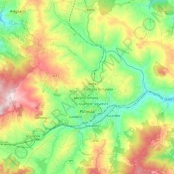
Nom : Carte topographique Potenza, altitude, relief.
Lieu : Potenza, Basilicata, Italy (40.58025 15.70628 40.74174 15.90302)
Altitude moyenne : 872 m
Altitude minimum : 574 m
Altitude maximum : 1 347 m
The first settlement of Potentia (Potenza's original Latin name) was probably located at a lower elevation than at present, some 10 kilometres (6 miles) south of today's Potenza. The Lucani of Potentia sided against Rome's enemies during the latter's wars against the Samnites and the Bruttii. Subjugated during the 4th century BC (later gaining the status of municipium), the Potentini rebelled after the Roman defeat at Cannae in 216 BC. However, the Battle of the Metaurus marked the end of any Carthaginian aspirations in Italy and Potentia was reconquered by the Romans and reduced to the status of military colony.
Autres cartes topographiques
Cliquez sur une carte pour visualiser sa topographie, son altitude et son relief.
Castelsaraceno
Italy > Basilicata > Potenza
Castelsaraceno, Potenza, Basilicata, Italy
Altitude moyenne : 1 104 m
Viadotto Pantanelle
Italy > Basilicata > Potenza > Nemoli
Viadotto Pantanelle, Nemoli, Potenza, Basilicata, Italy
Altitude moyenne : 1 685 m
Porco Morto
Italy > Basilicata > Potenza > Picerno > Porco Morto
Porco Morto, Picerno, Potenza, Basilicata, Italy
Altitude moyenne : 1 071 m
Balvano
Italy > Basilicata > Potenza > Balvano
Balvano, Potenza, Basilicata, Italy
Altitude moyenne : 621 m