
Carte topographique Lake County
Carte interactive
Cliquez sur la carte pour afficher l’altitude.
À propos de cette carte
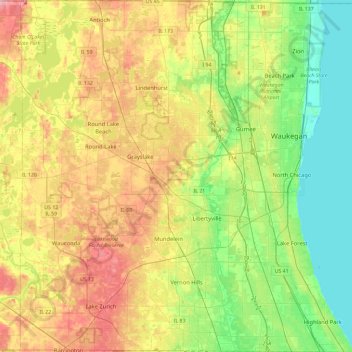
Nom : Carte topographique Lake County, altitude, relief.
Lieu : Lake County, Illinois, USA (42.15231 -88.19954 42.49563 -87.74949)
Altitude moyenne : 222 m
Altitude minimum : 173 m
Altitude maximum : 293 m
Autres cartes topographiques
Cliquez sur une carte pour visualiser sa topographie, son altitude et son relief.
Highland Park
USA > Illinois > Highland Park
Highland Park, Lake County, Illinois, 60035, USA
Altitude moyenne : 194 m
Mount Prospect
USA > Illinois > Mount Prospect
Mount Prospect, Cook County, Illinois, USA
Altitude moyenne : 205 m
Montague Island
Montague Island, Rockford, Winnebago County, Illinois, 61104, USA
Altitude moyenne : 254 m