
Carte topographique Lupfer Glacier
Carte interactive
Cliquez sur la carte pour afficher l’altitude.
À propos de cette carte
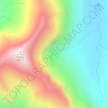
Nom : Carte topographique Lupfer Glacier, altitude, relief.
Lieu : Lupfer Glacier, Coal Creek, Flathead County, Montana, USA (48.47714 -113.51238 48.47724 -113.51228)
Altitude moyenne : 2 047 m
Altitude minimum : 1 493 m
Altitude maximum : 2 873 m
Autres cartes topographiques
Cliquez sur une carte pour visualiser sa topographie, son altitude et son relief.
Elkhorn Hot Springs
USA > Montana > Elkhorn Hot Springs
Elkhorn Hot Springs, Beaverhead County, Montana, 59646, USA
Altitude moyenne : 2 262 m
Blackwell Glacier
Blackwell Glacier, Leigh Lake Trail, Lincoln County, Montana, USA
Altitude moyenne : 2 114 m
Young Man Lake
Young Man Lake, Oldman Lake, Glacier County, Montana, USA
Altitude moyenne : 2 169 m
Weasel Collar Glacier
Weasel Collar Glacier, Bowman Lake, Flathead County, Montana, USA
Altitude moyenne : 2 290 m
North Swiftcurrent Glacier
North Swiftcurrent Glacier, Swiftcurrent Lookout Trail, Flathead County, Montana, USA
Altitude moyenne : 2 051 m
Miche Wabun Glacier
Miche Wabun Glacier, Goat Haunt Overlook, Glacier County, Montana, USA
Altitude moyenne : 2 177 m
Agassiz Glacier
USA > Montana > Wurtz Hill
Agassiz Glacier, Boulder Pass, Wurtz Hill, Flathead County, Montana, USA
Altitude moyenne : 2 376 m
Sperry Glacier
Sperry Glacier, Sperry Lake, Flathead County, Montana, USA
Altitude moyenne : 2 382 m
Whitecrow Glacier
Whitecrow Glacier, Stoney Indian Pass, Glacier County, Montana, USA
Altitude moyenne : 2 339 m
Cabinet Mountains Wilderness Area
Cabinet Mountains Wilderness Area, Sanders County, Montana, USA
Altitude moyenne : 1 247 m
Siyeh Glacier
Siyeh Glacier, Piegan Pass Trail, Glacier County, Montana, USA
Altitude moyenne : 2 341 m
Castle Rock Glacier
Castle Rock Glacier, Carbon County, Montana, USA
Altitude moyenne : 3 463 m
Blacktail Mountains
Blacktail Mountains, Beaverhead County, Montana, USA
Altitude moyenne : 2 697 m
Pumpkin Glacier
Pumpkin Glacier, Jackson Glacier, Glacier County, Montana, USA
Altitude moyenne : 2 316 m
Boulder Glacier
USA > Montana > Wurtz Hill
Boulder Glacier, Boulder Pass, Wurtz Hill, Flathead County, Montana, USA
Altitude moyenne : 2 105 m
Pumpelly Glacier
Pumpelly Glacier, Jackson Glacier, Glacier County, Montana, USA
Altitude moyenne : 2 326 m
Two Ocean Glacier
Two Ocean Glacier, Logging Lake, Flathead County, Montana, USA
Altitude moyenne : 2 331 m
Salamander Glacier
Salamander Glacier, Garden Wall Trail, Flathead County, Montana, USA
Altitude moyenne : 2 102 m
Ahern Glacier
Ahern Glacier, Highline Trail, Flathead County, Montana, USA
Altitude moyenne : 2 214 m
Red Eagle Glacier
Red Eagle Glacier, Nyack Creek, Nyack, Flathead County, Montana, USA
Altitude moyenne : 2 100 m
Ipasha Glacier
Ipasha Glacier, Highline Trail, Flathead County, Montana, USA
Altitude moyenne : 2 122 m
Thunderbird Glacier
USA > Montana > Wurtz Hill
Thunderbird Glacier, Boulder Pass, Wurtz Hill, Flathead County, Montana, USA
Altitude moyenne : 2 162 m
Swiftcurrent Glacier
Swiftcurrent Glacier, Garden Wall Trail, Flathead County, Montana, USA
Altitude moyenne : 2 062 m
Devils Slide
Devils Slide, Many Glacier Road, Babb, Glacier County, Montana, 59411, USA
Altitude moyenne : 1 502 m
Piegan Glacier
Piegan Glacier, Piegan Pass Trail, Glacier County, Montana, USA
Altitude moyenne : 2 222 m
Old Sun Glacier
Old Sun Glacier, Stoney Indian Pass, Glacier County, Montana, USA
Altitude moyenne : 2 285 m
Kintla Glacier
USA > Montana > Wurtz Hill
Kintla Glacier, Boulder Pass, Wurtz Hill, Flathead County, Montana, USA
Altitude moyenne : 2 336 m
Grasshopper Glacier
Grasshopper Glacier, Carbon County, Montana, USA
Altitude moyenne : 3 407 m
Shepard Glacier
Shepard Glacier, Highline Trail, Flathead County, Montana, USA
Altitude moyenne : 2 156 m
Rainbow Glacier
Rainbow Glacier, Bowman Lake, Flathead County, Montana, USA
Altitude moyenne : 2 400 m
Sexton Glacier
Sexton Glacier, Siyeh Pass, Glacier County, Montana, USA
Altitude moyenne : 2 256 m
Dixon Glacier
USA > Montana > Wurtz Hill
Dixon Glacier, Boulder Pass, Wurtz Hill, Flathead County, Montana, USA
Altitude moyenne : 2 192 m
Harris Glacier
USA > Montana > Wurtz Hill
Harris Glacier, Boulder Pass, Wurtz Hill, Flathead County, Montana, USA
Altitude moyenne : 2 138 m
Chaney Glacier
Chaney Glacier, Highline Trail, Flathead County, Montana, USA
Altitude moyenne : 2 169 m